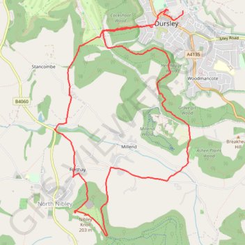
Tyndale from Dursley
Loop hike via Cockshoot Wood, Tyndale Monument, Nibley Knoll, Ashen Plains Wood, Gravelpit Wood and Hermitage Wood in the Cotswolds National Landscape. #Hiking #Loop #Nature #Forest #Countryside #Cotswolds
- Distance: 7.0 mi
- Elevation gain: 1,427 ft
- Maximum elevation: 659 ft
- Elevation loss: 1,476 ft
- Minimum elevation: 184 ft
- Moving time: 2 h 41 m
- Moving speed: 2.6 mph
- Maximum speed: 5.9 mph
- Total time: 3 h 47 m
- Global speed: 1.8 mph
Interactive trail map
Trail profile
- Distance: 7.0 mi
- Elevation gain: 1,427 ft
- Maximum elevation: 659 ft
- Elevation loss: 1,476 ft
- Minimum elevation: 184 ft
- Moving time: 2 h 41 m
- Moving speed: 2.6 mph
- Maximum speed: 5.9 mph
- Total time: 3 h 47 m
- Global speed: 1.8 mph
About this trail
Name: Tyndale from Dursley trail, distance, elevation, map, profile, GPS track
Coordinates: 51.65603 -2.37656 51.68285 -2.35054
Other hiking, mountain biking, running and outdoor activity trails
Click on a trail to view its statistics, map and profile.
Tyndale Monument loop from Wotton-under-Edge via Westridge Wood, Nibley Knoll and Wotton Hill in the Cotswolds National Landscape
United Kingdom > England > Gloucestershire > Wotton-under-Edge
The Tyndale Monument loop offers a delightful hiking experience through the scenic landscapes of the Cotswolds, featuring a mix of woodland trails, rolling hills, and expansive views from both Nibley Knoll and Wotton Hill. Along the way, hikers can explore the historic Tyndale Monument and enjoy the natural…
Distance: 5.0 mi • Elevation gain: 623 ft • Maximum elevation: 673 ft
Loop Walk between Dursley and North Nibley
United Kingdom > England > Gloucestershire > Dursley
Distance: 10.3 mi • Elevation gain: 1,427 ft • Maximum elevation: 712 ft
Coaley Peak to Dursley
United Kingdom > England > Gloucestershire > Stroud > Nympsfield > Cockadilly
Distance: 10.9 mi • Elevation gain: 1,837 ft • Maximum elevation: 794 ft
Coaley to Dursley loop walk
United Kingdom > England > Gloucestershire > Stroud > Nympsfield > Cockadilly
Distance: 10.2 mi • Elevation gain: 1,814 ft • Maximum elevation: 797 ft
Wotton-under-Edge Loop
United Kingdom > England > Gloucestershire > Wotton-under-Edge
Distance: 10.0 mi • Elevation gain: 1,266 ft • Maximum elevation: 784 ft
Crawley, Uley, Cam
United Kingdom > England > Gloucestershire > Stroud > Nympsfield > Cockadilly
Distance: 12.6 mi • Elevation gain: 1,982 ft • Maximum elevation: 814 ft
Dean2023-311
United Kingdom > England > Oxfordshire > Oxford
Distance: 192.8 mi • Elevation gain: 11,043 ft • Maximum elevation: 951 ft
Wotton NM
United Kingdom > England > Gloucestershire > Wotton-under-Edge
Distance: 11.7 mi • Elevation gain: 1,237 ft • Maximum elevation: 673 ft