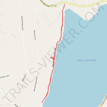
Lake Gleneida Walking Trail
- Distance: 1.4 mi
- Elevation gain: 151 ft
- Maximum elevation: 587 ft
- Elevation loss: 161 ft
- Minimum elevation: 515 ft
- Moving time: 26 m 15 s
- Moving speed: 3.3 mph
- Maximum speed: 4.7 mph
- Total time: 27 m 45 s
- Global speed: 3.1 mph
Interactive trail map
Trail profile
- Distance: 1.4 mi
- Elevation gain: 151 ft
- Maximum elevation: 587 ft
- Elevation loss: 161 ft
- Minimum elevation: 515 ft
- Moving time: 26 m 15 s
- Moving speed: 3.3 mph
- Maximum speed: 4.7 mph
- Total time: 27 m 45 s
- Global speed: 3.1 mph
About this trail
Name: Lake Gleneida Walking Trail trail, distance, elevation, map, profile, GPS track
Coordinates: 41.41622 -73.68918 41.42582 -73.68623
Topography: Putnam County topographic map, elevation, terrain
Other hiking, mountain biking, running and outdoor activity trails
Click on a trail to view its statistics, map and profile.