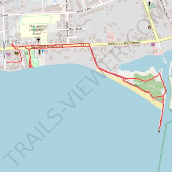
Walk - Wellington shoreline
Canada, ON, Wellington
- Distance: 1.9 mi
- Elevation gain: 82 ft
- Maximum elevation: 279 ft
- Elevation loss: 72 ft
- Minimum elevation: 243 ft
- Moving time: 53 m 12 s
- Moving speed: 2.2 mph
- Maximum speed: 2.9 mph
- Total time: 1 h 6 m
- Global speed: 1.7 mph
Interactive trail map
Trail profile
- Distance: 1.9 mi
- Elevation gain: 82 ft
- Maximum elevation: 279 ft
- Elevation loss: 72 ft
- Minimum elevation: 243 ft
- Moving time: 53 m 12 s
- Moving speed: 2.2 mph
- Maximum speed: 2.9 mph
- Total time: 1 h 6 m
- Global speed: 1.7 mph
About this trail
Name: Walk - Wellington shoreline trail, distance, elevation, map, profile, GPS track
Coordinates: 43.94753 -77.34947 43.95201 -77.33787
Other hiking, mountain biking, running and outdoor activity trails
Click on a trail to view its statistics, map and profile.
Cobourg - Adolphustown
Canada > Ontario > Northumberland County > Cobourg
Lake Ontario. #Bike #Cobourg #Adolphustown #Ontario
Distance: 71.0 mi • Elevation gain: 1,473 ft • Maximum elevation: 390 ft