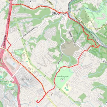
Patapsco Valley State Park - Ellicott City
- Distance: 7.9 mi
- Elevation gain: 840 ft
- Maximum elevation: 486 ft
- Elevation loss: 840 ft
- Minimum elevation: 141 ft
- Moving time: 1 h 48 m
- Moving speed: 4.3 mph
- Maximum speed: 12.5 mph
- Total time: 2 h 7 m
- Global speed: 3.7 mph
Interactive trail map
Trail profile
- Distance: 7.9 mi
- Elevation gain: 840 ft
- Maximum elevation: 486 ft
- Elevation loss: 840 ft
- Minimum elevation: 141 ft
- Moving time: 1 h 48 m
- Moving speed: 4.3 mph
- Maximum speed: 12.5 mph
- Total time: 2 h 7 m
- Global speed: 3.7 mph
About this trail
Name: Patapsco Valley State Park - Ellicott City trail, distance, elevation, map, profile, GPS track
Coordinates: 39.23915 -76.81971 39.27021 -76.78197
Topography: Howard County topographic map, elevation, terrain
Other hiking, mountain biking, running and outdoor activity trails
Click on a trail to view its statistics, map and profile.
Old Ellicott City / OEC Connector Trail
United States > Maryland > Howard County > Ellicott City
Distance: 4.2 mi • Elevation gain: 489 ft • Maximum elevation: 387 ft
Patapsco Valley State Park Ilchester Area Loop
United States > Maryland > Howard County > Ilchester
Distance: 5.6 mi • Elevation gain: 1,033 ft • Maximum elevation: 358 ft
Hike through Patapsco Valley State Park Ilchester Area
United States > Maryland > Howard County > Ilchester
Distance: 5.3 mi • Elevation gain: 915 ft • Maximum elevation: 354 ft
St. Marys's College Ruins and Patapsco Valley State Park Illchester Area hike
United States > Maryland > Howard County > Ilchester
Distance: 3.0 mi • Elevation gain: 499 ft • Maximum elevation: 341 ft
Ellicott City - Meadowbrook Park
United States > Maryland > Howard County > Ellicott City
Distance: 7.5 mi • Elevation gain: 338 ft • Maximum elevation: 525 ft
Crossing Patapsco Valley State Park Ilchester Area
United States > Maryland > Howard County > Ilchester
Morning Hike
Distance: 3.6 mi • Elevation gain: 738 ft • Maximum elevation: 361 ft
Ellicott City - Meadowbrook Park Loop
United States > Maryland > Howard County > Ellicott City
Distance: 4.0 mi • Elevation gain: 200 ft • Maximum elevation: 436 ft
Patapsco Valley State Park - Horse Farm Area
United States > Maryland > Howard County > Ellicott City
Distance: 8.1 mi • Elevation gain: 787 ft • Maximum elevation: 371 ft
Patapsco Valley State Park Ilchester Area
United States > Maryland > Howard County > Ilchester
Morning Hike
Distance: 4.8 mi • Elevation gain: 856 ft • Maximum elevation: 358 ft
Patapsco Valley State Park Ilchester Area
United States > Maryland > Howard County > Ilchester
Morning Hike
Distance: 4.5 mi • Elevation gain: 705 ft • Maximum elevation: 354 ft
Old Ilchester Quarry Scouting
United States > Maryland > Howard County > Ilchester
Patapsco Valley State Park - Morning Hike
Distance: 5.2 mi • Elevation gain: 958 ft • Maximum elevation: 354 ft
Scouting Old Ilchester
United States > Maryland > Howard County > Ilchester
Morning Hike
Distance: 4.9 mi • Elevation gain: 837 ft • Maximum elevation: 354 ft
Scouting Old Ilchester
United States > Maryland > Howard County > Ilchester
Morning Hike
Distance: 4.9 mi • Elevation gain: 735 ft • Maximum elevation: 354 ft