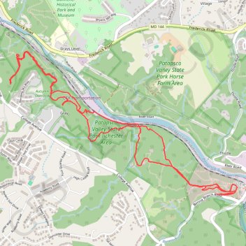
Hike through Patapsco Valley State Park Ilchester Area
- Distance: 5.3 mi
- Elevation gain: 915 ft
- Maximum elevation: 354 ft
- Elevation loss: 909 ft
- Minimum elevation: 138 ft
- Moving time: 2 h 12 m
- Moving speed: 2.4 mph
- Maximum speed: 6.6 mph
- Total time: 2 h 36 m
- Global speed: 2.0 mph
Interactive trail map
Trail profile
- Distance: 5.3 mi
- Elevation gain: 915 ft
- Maximum elevation: 354 ft
- Elevation loss: 909 ft
- Minimum elevation: 138 ft
- Moving time: 2 h 12 m
- Moving speed: 2.4 mph
- Maximum speed: 6.6 mph
- Total time: 2 h 36 m
- Global speed: 2.0 mph
About this trail
Name: Hike through Patapsco Valley State Park Ilchester Area trail, distance, elevation, map, profile, GPS track
Coordinates: 39.24999 -76.79184 39.26283 -76.76554
Topography: Howard County topographic map, elevation, terrain
Other hiking, mountain biking, running and outdoor activity trails
Click on a trail to view its statistics, map and profile.
St. Mary’s College and Chapel Ruins Loop in Patapsco Valley State Park Ilchester Area
United States > Maryland > Howard County > Ilchester
The St. Mary’s College and Chapel Ruins Loop offers hikers a unique blend of nature and history, showcasing the remnants of a once-grand seminary that dates back to the late 19th century. As you walk along the trail, you’ll encounter intriguing ruins, including stone remnants and a striking metal cross,…
Distance: 2.1 mi • Elevation gain: 269 ft • Maximum elevation: 381 ft
Patapsco Valley State Park Ilchester Area Loop
United States > Maryland > Howard County > Ilchester
Distance: 5.6 mi • Elevation gain: 1,033 ft • Maximum elevation: 358 ft
Patapsco Valley State Park Hilton Area
United States > Maryland > Baltimore County > Catonsville
Distance: 5.5 mi • Elevation gain: 787 ft • Maximum elevation: 404 ft
St. Marys's College Ruins and Patapsco Valley State Park Illchester Area hike
United States > Maryland > Howard County > Ilchester
Distance: 3.0 mi • Elevation gain: 499 ft • Maximum elevation: 341 ft
Crossing Patapsco Valley State Park Ilchester Area
United States > Maryland > Howard County > Ilchester
Morning Hike
Distance: 3.6 mi • Elevation gain: 738 ft • Maximum elevation: 361 ft
Patapsco Valley State Park Hilton Area Loop
United States > Maryland > Baltimore County > Catonsville
Distance: 6.2 mi • Elevation gain: 823 ft • Maximum elevation: 410 ft
Patapsco Valley State Park - Horse Farm Area
United States > Maryland > Howard County > Ellicott City
Distance: 8.1 mi • Elevation gain: 787 ft • Maximum elevation: 371 ft
Patapsco Valley State Park Ilchester Area
United States > Maryland > Howard County > Ilchester
Morning Hike
Distance: 4.8 mi • Elevation gain: 856 ft • Maximum elevation: 358 ft
Patapsco Valley State Park Ilchester Area
United States > Maryland > Howard County > Ilchester
Morning Hike
Distance: 4.5 mi • Elevation gain: 705 ft • Maximum elevation: 354 ft
Old Ilchester Quarry Scouting
United States > Maryland > Howard County > Ilchester
Patapsco Valley State Park - Morning Hike
Distance: 5.2 mi • Elevation gain: 958 ft • Maximum elevation: 354 ft
Patapsco Valley State Park
United States > Maryland > Baltimore County > Catonsville
Morning Loop Hike
Distance: 6.1 mi • Elevation gain: 1,050 ft • Maximum elevation: 410 ft
Scouting Old Ilchester
United States > Maryland > Howard County > Ilchester
Morning Hike
Distance: 4.9 mi • Elevation gain: 837 ft • Maximum elevation: 354 ft
Scouting Old Ilchester
United States > Maryland > Howard County > Ilchester
Morning Hike
Distance: 4.9 mi • Elevation gain: 735 ft • Maximum elevation: 354 ft
Morning Hike
United States > Maryland > Baltimore County > Catonsville
Distance: 5.9 mi • Elevation gain: 732 ft • Maximum elevation: 404 ft
Patapsco Valley State Park - Ellicott City
United States > Maryland > Howard County > Ellicott City
Distance: 7.9 mi • Elevation gain: 840 ft • Maximum elevation: 486 ft