Make a donation
Gear up for your next adventure:
As an Amazon Associate, this site earns from qualifying purchases at no extra cost to you.
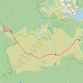
Cope Hut to Mount Jaithmatang and Tawanga Huts in Autralian Alps
- Distance: 9.3 mi
- Elevation gain: 1,296 ft
- Maximum elevation: 5,991 ft
- Elevation loss: 1,388 ft
- Minimum elevation: 5,384 ft
- Moving time: 3 h 58 m
- Moving speed: 2.3 mph
- Maximum speed: 3.2 mph
- Total time: 8 h 51 m
- Global speed: 1.1 mph
Interactive trail map
Make a donation
Gear up for your next adventure:
As an Amazon Associate, this site earns from qualifying purchases at no extra cost to you.
Trail profile
- Distance: 9.3 mi
- Elevation gain: 1,296 ft
- Maximum elevation: 5,991 ft
- Elevation loss: 1,388 ft
- Minimum elevation: 5,384 ft
- Moving time: 3 h 58 m
- Moving speed: 2.3 mph
- Maximum speed: 3.2 mph
- Total time: 8 h 51 m
- Global speed: 1.1 mph
Make a donation
Gear up for your next adventure:
As an Amazon Associate, this site earns from qualifying purchases at no extra cost to you.
About this trail
Name: Cope Hut to Mount Jaithmatang and Tawanga Huts in Autralian Alps trail, distance, elevation, map, profile, GPS track
Start: Cope Hut Track, Nelse, Shire of East Gippsland, Victoria, Australia (-36.90734 147.29347)
End: Fainter Firetrail, Falls Creek, Alpine Shire, Victoria, 3699, Australia (-36.89768 147.20281)
Coordinates: -36.92608 147.19217 -36.89024 147.29347
Make a donation
Gear up for your next adventure:
As an Amazon Associate, this site earns from qualifying purchases at no extra cost to you.
Other hiking, mountain biking, running and outdoor activity trails
Click on a trail to view its statistics, map and profile.
Fainter Firetrail to Mount Fainter in Alpine National Park
Australia > Victoria > Falls Creek Alpine Resort > Falls Creek
Distance: 25.4 mi • Elevation gain: 3,140 ft • Maximum elevation: 6,027 ft
Make a donation
Gear up for your next adventure:
As an Amazon Associate, this site earns from qualifying purchases at no extra cost to you.
Mount Jaithmathang to Falls Creek
Falls, Jaithmathang, Bogong
Distance: 9.5 mi • Elevation gain: 1,703 ft • Maximum elevation: 5,991 ft
Tawonga Huts to Rocky Valley Storage via Pretty Valley Pondage in Australian Alps
Distance: 7.3 mi • Elevation gain: 1,027 ft • Maximum elevation: 5,935 ft
Rocky Valley Storage to Cope Hut in Austalian Alps
Distance: 10.0 mi • Elevation gain: 1,348 ft • Maximum elevation: 5,830 ft
Ski Up to Mount Cope
Mount Cope Ski Track
Distance: 1.1 mi • Elevation gain: 440 ft • Maximum elevation: 5,958 ft
Make a donation
Gear up for your next adventure:
As an Amazon Associate, this site earns from qualifying purchases at no extra cost to you.