Thank you for supporting this site ❤️
Make a donation
Make a donation
Gear up for your next adventure:
As an Amazon Associate, this site earns from qualifying purchases at no extra cost to you.
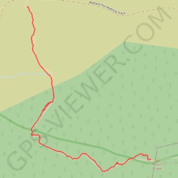
Ski Up to Mount Cope
Mount Cope Ski Track
- Distance: 1.1 mi
- Elevation gain: 440 ft
- Maximum elevation: 5,958 ft
- Elevation loss: 13 ft
- Minimum elevation: 5,531 ft
- Moving time: 36 m
- Moving speed: 1.9 mph
- Maximum speed: 6.4 mph
- Total time: 1 h 10 m
- Global speed: 1.0 mph
Interactive trail map
Thank you for supporting this site ❤️
Make a donation
Make a donation
Gear up for your next adventure:
As an Amazon Associate, this site earns from qualifying purchases at no extra cost to you.
Trail profile
- Distance: 1.1 mi
- Elevation gain: 440 ft
- Maximum elevation: 5,958 ft
- Elevation loss: 13 ft
- Minimum elevation: 5,531 ft
- Moving time: 36 m
- Moving speed: 1.9 mph
- Maximum speed: 6.4 mph
- Total time: 1 h 10 m
- Global speed: 1.0 mph
Thank you for supporting this site ❤️
Make a donation
Make a donation
Gear up for your next adventure:
As an Amazon Associate, this site earns from qualifying purchases at no extra cost to you.
About this trail
Name: Ski Up to Mount Cope trail, distance, elevation, map, profile, GPS track
Coordinates: -36.92762 147.27306 -36.91946 147.28074
Thank you for supporting this site ❤️
Make a donation
Make a donation
Gear up for your next adventure:
As an Amazon Associate, this site earns from qualifying purchases at no extra cost to you.
Other hiking, mountain biking, running and outdoor activity trails
Click on a trail to view its statistics, map and profile.
Cope Hut to Mount Jaithmatang and Tawanga Huts in Autralian Alps
Distance: 9.3 mi • Elevation gain: 1,296 ft • Maximum elevation: 5,991 ft
Thank you for supporting this site ❤️
Make a donation
Make a donation
Gear up for your next adventure:
As an Amazon Associate, this site earns from qualifying purchases at no extra cost to you.