Make a donation
Gear up for your next adventure:
As an Amazon Associate, this site earns from qualifying purchases at no extra cost to you.
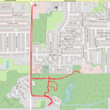
2026-04-11_16-14_Sat_trail_walk
- Distance: 3.3 mi
- Elevation gain: 141 ft
- Maximum elevation: 735 ft
- Elevation loss: 148 ft
- Minimum elevation: 686 ft
- Moving time: 39 m 42 s
- Moving speed: 5.0 mph
- Maximum speed: 45.5 mph
- Total time: 52 m 30 s
- Global speed: 3.8 mph
Interactive trail map
Make a donation
Gear up for your next adventure:
As an Amazon Associate, this site earns from qualifying purchases at no extra cost to you.
Trail profile
- Distance: 3.3 mi
- Elevation gain: 141 ft
- Maximum elevation: 735 ft
- Elevation loss: 148 ft
- Minimum elevation: 686 ft
- Moving time: 39 m 42 s
- Moving speed: 5.0 mph
- Maximum speed: 45.5 mph
- Total time: 52 m 30 s
- Global speed: 3.8 mph
Make a donation
Gear up for your next adventure:
As an Amazon Associate, this site earns from qualifying purchases at no extra cost to you.
About this trail
Name: 2026-04-11_16-14_Sat_trail_walk trail, distance, elevation, map, profile, GPS track
Coordinates: 34.71822 -86.76810 34.72856 -86.76207
Topography: Madison County topographic map, elevation, terrain
Make a donation
Gear up for your next adventure:
As an Amazon Associate, this site earns from qualifying purchases at no extra cost to you.
Other hiking, mountain biking, running and outdoor activity trails
Click on a trail to view its statistics, map and profile.
13 Mile Bike, Madison, AL
United States > Alabama > Madison County > Madison
Distance: 13.0 mi • Elevation gain: 420 ft • Maximum elevation: 728 ft
10 Mile Run, Madison AL
United States > Alabama > Madison County > Madison
Lunch Run
Distance: 10.2 mi • Elevation gain: 328 ft • Maximum elevation: 728 ft
Bicycle-Madison AL
United States > Alabama > Madison County > Madison
Afternoon Ride
Distance: 10.3 mi • Elevation gain: 338 ft • Maximum elevation: 728 ft