Make a donation
Gear up for your next adventure:
As an Amazon Associate, this site earns from qualifying purchases at no extra cost to you.
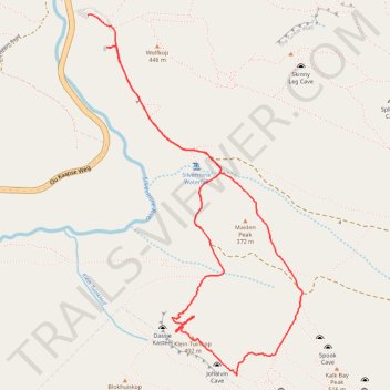
Klein-Tuinkop Loop Trail in Cape Floral Region Protected Areas
- Distance: 4.6 mi
- Elevation gain: 1,132 ft
- Maximum elevation: 1,565 ft
- Elevation loss: 1,142 ft
- Minimum elevation: 866 ft
- Moving time: 2 h 31 m
- Moving speed: 1.8 mph
- Maximum speed: 4.1 mph
- Total time: 4 h 3 m
- Global speed: 1.1 mph
Interactive trail map
Make a donation
Gear up for your next adventure:
As an Amazon Associate, this site earns from qualifying purchases at no extra cost to you.
Trail profile
- Distance: 4.6 mi
- Elevation gain: 1,132 ft
- Maximum elevation: 1,565 ft
- Elevation loss: 1,142 ft
- Minimum elevation: 866 ft
- Moving time: 2 h 31 m
- Moving speed: 1.8 mph
- Maximum speed: 4.1 mph
- Total time: 4 h 3 m
- Global speed: 1.1 mph
Make a donation
Gear up for your next adventure:
As an Amazon Associate, this site earns from qualifying purchases at no extra cost to you.
About this trail
Name: Klein-Tuinkop Loop Trail in Cape Floral Region Protected Areas trail, distance, elevation, map, profile, GPS track
Coordinates: -34.11280 18.42129 -34.09092 18.43703
Make a donation
Gear up for your next adventure:
As an Amazon Associate, this site earns from qualifying purchases at no extra cost to you.
Other hiking, mountain biking, running and outdoor activity trails
Click on a trail to view its statistics, map and profile.
Simon's Town - Cape Town
South Africa > Western Cape > City of Cape Town > Simon's Town
#Bike
Distance: 33.5 mi • Elevation gain: 3,698 ft • Maximum elevation: 604 ft
High Steenberg via Wolfkop
South Africa > Western Cape > City of Cape Town
This relatively easy hike begins with a short but steep, unexposed scramble up to Wolfkop. From there, you follow a circular route that takes you past Steenberg Peak with panoramic views of the surrounding mountains, valleys, and the coastline in the distance.
Distance: 2.2 mi • Elevation gain: 791 ft • Maximum elevation: 1,755 ft