Mount Moosilauke Loop via South Peak in White Mountain National Forest
The Mount Moosilauke Loop offers a rewarding hiking experience with diverse terrains and stunning views throughout the journey. Hikers will traverse rocky paths through dense forest, with occasional views opening up to alpine landscapes as they approach the summit. At the top, panoramic vistas stretch across the White Mountains and beyond, with the surrounding ridgelines and valleys providing a spectacular backdrop for a memorable hike. Depending on the trail chosen, the route may also lead to nearby South Peak, offering even more impressive views of Moosilauke and the Pemi Wilderness. #Hiking #Mountain #Loop #Overlook #Forest #Nature
- Distance: 7.4 mi
- Elevation gain: 2,398 ft
- Maximum elevation: 4,783 ft
- Elevation loss: 2,464 ft
- Minimum elevation: 2,392 ft
- Moving time: 4 h 38 m
- Moving speed: 1.6 mph
- Maximum speed: 3.6 mph
- Total time: 5 h 41 m
- Global speed: 1.3 mph
Interactive trail map
Trail profile
- Distance: 7.4 mi
- Elevation gain: 2,398 ft
- Maximum elevation: 4,783 ft
- Elevation loss: 2,464 ft
- Minimum elevation: 2,392 ft
- Moving time: 4 h 38 m
- Moving speed: 1.6 mph
- Maximum speed: 3.6 mph
- Total time: 5 h 41 m
- Global speed: 1.3 mph
About this trail
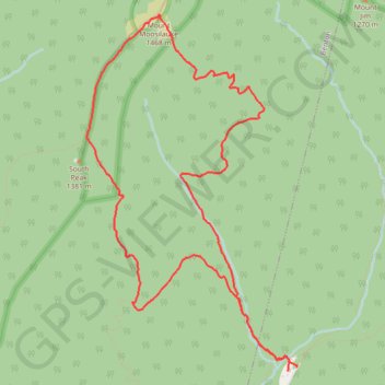
Name: Mount Moosilauke Loop via South Peak in White Mountain National Forest trail, distance, elevation, map, profile, GPS track
Start: Ravine Road, Woodstock, Grafton County, New Hampshire, United States (43.99356 -71.81514)
Coordinates: 43.99329 -71.83998 44.02363 -71.81492
Topography: Grafton County topographic map, elevation, terrain
Other hiking, mountain biking, running and outdoor activity trails
Click on a trail to view its statistics, map and profile.
Mount Moosilauke Loop in White Mountain National Forest
United States > New Hampshire > Grafton County > Woodstock
Embarking on the Mount Moosilauke Loop via the Gorge Brook Trail, Carriage Road, and South Peak offers hikers a journey through diverse terrains, from serene forested paths alongside Gorge Brook to the expansive, open summit of Mount Moosilauke. The treeless peak provides panoramic views of the surrounding…
Distance: 7.2 mi • Elevation gain: 2,405 ft • Maximum elevation: 4,780 ft