Maligne Lake - Moose Lake
Interactive trail map
Trail profile
- Distance: 3.4 mi
- Elevation gain: 302 ft
- Maximum elevation: 5,650 ft
- Elevation loss: 315 ft
- Minimum elevation: 5,505 ft
About this trail
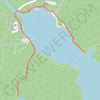
Name: Maligne Lake - Moose Lake trail, distance, elevation, map, profile, GPS track
Start: Mary Schaeffer Loop, Improvement District No. 12, Alberta, Canada (52.72934 -117.63780)
End: Maligne Lake road, Improvement District No. 12, Alberta, Canada (52.72839 -117.64204)
Coordinates: 52.71768 -117.64487 52.72941 -117.62994
Other hiking, mountain biking, running and outdoor activity trails
Click on a trail to view its statistics, map and profile.
Jasper National Park - Skyline Trail
Canada > Alberta > Improvement District No. 12
Distance: 30.1 mi • Elevation gain: 5,981 ft • Maximum elevation: 8,343 ft