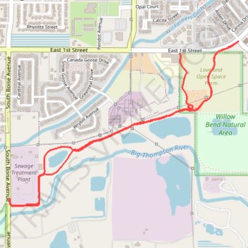
Willow Bend Natural Area
- Distance: 3.0 mi
- Elevation gain: 121 ft
- Maximum elevation: 4,941 ft
- Elevation loss: 89 ft
- Minimum elevation: 4,898 ft
- Moving time: 28 m 55 s
- Moving speed: 6.2 mph
- Maximum speed: 16.6 mph
- Total time: 31 m 8 s
- Global speed: 5.8 mph
Interactive trail map
Trail profile
- Distance: 3.0 mi
- Elevation gain: 121 ft
- Maximum elevation: 4,941 ft
- Elevation loss: 89 ft
- Minimum elevation: 4,898 ft
- Moving time: 28 m 55 s
- Moving speed: 6.2 mph
- Maximum speed: 16.6 mph
- Total time: 31 m 8 s
- Global speed: 5.8 mph
About this trail
Name: Willow Bend Natural Area trail, distance, elevation, map, profile, GPS track
Coordinates: 40.38369 -105.05419 40.39325 -105.03673
Topography: Loveland topographic map, elevation, terrain
Other hiking, mountain biking, running and outdoor activity trails
Click on a trail to view its statistics, map and profile.
Willow Bend Natural Area Loop
United States > Colorado > Larimer County > Loveland
Distance: 1.4 mi • Elevation gain: 72 ft • Maximum elevation: 4,938 ft