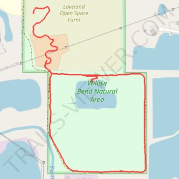
Willow Bend Natural Area Loop
- Distance: 1.4 mi
- Elevation gain: 72 ft
- Maximum elevation: 4,938 ft
- Elevation loss: 49 ft
- Minimum elevation: 4,875 ft
- Moving time: 36 m 10 s
- Moving speed: 2.3 mph
- Maximum speed: 3.7 mph
- Total time: 40 m 9 s
- Global speed: 2.1 mph
Interactive trail map
Trail profile
- Distance: 1.4 mi
- Elevation gain: 72 ft
- Maximum elevation: 4,938 ft
- Elevation loss: 49 ft
- Minimum elevation: 4,875 ft
- Moving time: 36 m 10 s
- Moving speed: 2.3 mph
- Maximum speed: 3.7 mph
- Total time: 40 m 9 s
- Global speed: 2.1 mph
About this trail
Name: Willow Bend Natural Area Loop trail, distance, elevation, map, profile, GPS track
Start: East 1st Street, Loveland, Larimer County, Colorado, 80537, United States (40.38953 -105.04012)
End: East 1st Street, Loveland, Larimer County, Colorado, 80537, United States (40.39121 -105.04074)
Coordinates: 40.38552 -105.04076 40.39145 -105.03547
Topography: Loveland topographic map, elevation, terrain
Other hiking, mountain biking, running and outdoor activity trails
Click on a trail to view its statistics, map and profile.
Willow Bend Natural Area
United States > Colorado > Larimer County > Loveland
Distance: 3.0 mi • Elevation gain: 121 ft • Maximum elevation: 4,941 ft