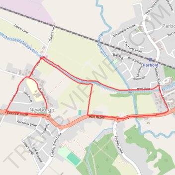
Parbold - Newburgh - Leeds and Liverpool Canal
- Distance: 2.4 mi
- Elevation gain: 128 ft
- Maximum elevation: 112 ft
- Elevation loss: 128 ft
- Minimum elevation: 43 ft
- Moving time: 57 m 22 s
- Moving speed: 2.6 mph
- Maximum speed: 3.6 mph
- Total time: 1 h 50 s
- Global speed: 2.4 mph
Interactive trail map
Trail profile
- Distance: 2.4 mi
- Elevation gain: 128 ft
- Maximum elevation: 112 ft
- Elevation loss: 128 ft
- Minimum elevation: 43 ft
- Moving time: 57 m 22 s
- Moving speed: 2.6 mph
- Maximum speed: 3.6 mph
- Total time: 1 h 50 s
- Global speed: 2.4 mph
About this trail
Name: Parbold - Newburgh - Leeds and Liverpool Canal trail, distance, elevation, map, profile, GPS track
Coordinates: 53.58665 -2.78835 53.59111 -2.76899
Other hiking, mountain biking, running and outdoor activity trails
Click on a trail to view its statistics, map and profile.
Leeds-Liverpool Canal, Parbold to Burscough Bridge
United Kingdom > England > Lancashire > West Lancashire > Parbold
Distance: 4.8 mi • Elevation gain: 95 ft • Maximum elevation: 75 ft
Parbold - Leeds and Liverpool Canal Loop Walk
United Kingdom > England > Lancashire > West Lancashire > Parbold
Distance: 3.3 mi • Elevation gain: 200 ft • Maximum elevation: 164 ft
Leeds and Liverpool Canal between Parbold and Appley Bridge
United Kingdom > England > Lancashire > West Lancashire > Parbold
Distance: 2.8 mi • Elevation gain: 118 ft • Maximum elevation: 112 ft
Parbold - Leeds and Liverpool Canal
United Kingdom > England > Lancashire > West Lancashire > Parbold
Distance: 2.4 mi • Elevation gain: 98 ft • Maximum elevation: 115 ft
Newburgh Parbold loop
United Kingdom > England > Lancashire > West Lancashire > Newburgh
West Lancashire Walk
Distance: 2.4 mi • Elevation gain: 89 ft • Maximum elevation: 112 ft
Newburgh
United Kingdom > England > Lancashire > West Lancashire > Parbold
Distance: 2.6 mi • Elevation gain: 98 ft • Maximum elevation: 112 ft