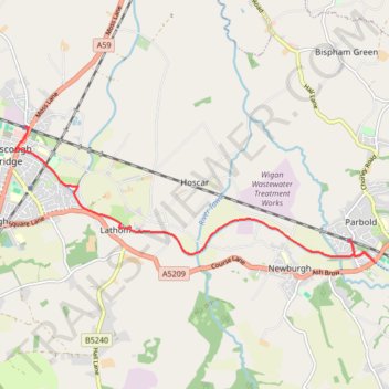
Leeds-Liverpool Canal, Parbold to Burscough Bridge
- Distance: 4.8 mi
- Elevation gain: 95 ft
- Maximum elevation: 75 ft
- Elevation loss: 92 ft
- Minimum elevation: 49 ft
- Moving time: 1 h 46 m
- Moving speed: 2.7 mph
- Maximum speed: 5.8 mph
- Total time: 3 h 30 m
- Global speed: 1.4 mph
Interactive trail map
Trail profile
- Distance: 4.8 mi
- Elevation gain: 95 ft
- Maximum elevation: 75 ft
- Elevation loss: 92 ft
- Minimum elevation: 49 ft
- Moving time: 1 h 46 m
- Moving speed: 2.7 mph
- Maximum speed: 5.8 mph
- Total time: 3 h 30 m
- Global speed: 1.4 mph
About this trail
Name: Leeds-Liverpool Canal, Parbold to Burscough Bridge trail, distance, elevation, map, profile, GPS track
Coordinates: 53.58802 -2.84372 53.60546 -2.76563
Other hiking, mountain biking, running and outdoor activity trails
Click on a trail to view its statistics, map and profile.
Croston Burscough Bridge via Rufford along Leeds and Liverpool Canal
United Kingdom > England > Lancashire > Chorley > Croston > Cock Robin
Distance: 7.8 mi • Elevation gain: 157 ft • Maximum elevation: 105 ft
Parbold - Leeds and Liverpool Canal Loop Walk
United Kingdom > England > Lancashire > West Lancashire > Parbold
Distance: 3.3 mi • Elevation gain: 200 ft • Maximum elevation: 164 ft
Leeds and Liverpool Canal between Parbold and Appley Bridge
United Kingdom > England > Lancashire > West Lancashire > Parbold
Distance: 2.8 mi • Elevation gain: 118 ft • Maximum elevation: 112 ft
Parbold - Newburgh - Leeds and Liverpool Canal
United Kingdom > England > Lancashire > West Lancashire > Newburgh
Distance: 2.4 mi • Elevation gain: 128 ft • Maximum elevation: 112 ft
Parbold - Leeds and Liverpool Canal
United Kingdom > England > Lancashire > West Lancashire > Parbold
Distance: 2.4 mi • Elevation gain: 98 ft • Maximum elevation: 115 ft
Newburgh Parbold loop
United Kingdom > England > Lancashire > West Lancashire > Newburgh
West Lancashire Walk
Distance: 2.4 mi • Elevation gain: 89 ft • Maximum elevation: 112 ft
Newburgh
United Kingdom > England > Lancashire > West Lancashire > Parbold
Distance: 2.6 mi • Elevation gain: 98 ft • Maximum elevation: 112 ft