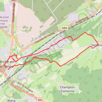
Promenade nr 2 - Paquerette (Marche en Famenne)
- Distance: 7.0 mi
- Elevation gain: 463 ft
- Maximum elevation: 1,040 ft
- Elevation loss: 430 ft
- Minimum elevation: 689 ft
- Moving time: 2 h 19 m
- Moving speed: 3.0 mph
- Maximum speed: 6.3 mph
- Total time: 2 h 29 m
- Global speed: 2.8 mph
Interactive trail map
Trail profile
- Distance: 7.0 mi
- Elevation gain: 463 ft
- Maximum elevation: 1,040 ft
- Elevation loss: 430 ft
- Minimum elevation: 689 ft
- Moving time: 2 h 19 m
- Moving speed: 3.0 mph
- Maximum speed: 6.3 mph
- Total time: 2 h 29 m
- Global speed: 2.8 mph
About this trail
Name: Promenade nr 2 - Paquerette (Marche en Famenne) trail, distance, elevation, map, profile, GPS track
Start: 21A, Avenue du Monument, Marche-en-Famenne, Luxembourg, Wallonia, 6900, Belgium (50.22480 5.34089)
End: 17A, Avenue du Monument, Marche-en-Famenne, Luxembourg, Wallonia, 6900, Belgium (50.22437 5.34204)
Coordinates: 50.22437 5.33948 50.23907 5.39828
Other hiking, mountain biking, running and outdoor activity trails
Click on a trail to view its statistics, map and profile.
Riethoven naar Oostenrijk
Netherlands > North Brabant > Riethoven > Eind
Distance: 573.0 mi • Elevation gain: 44,715 ft • Maximum elevation: 6,224 ft
Eurovelo 15 - Strasbourg Rotterdam
France > Grand Est > Bas-Rhin > Strasbourg
Distance: 554.1 mi • Elevation gain: 6,903 ft • Maximum elevation: 479 ft