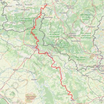
Dinant - Maasdal - Verdun
Interactive trail map
Trail profile
- Distance: 148.3 mi
- Elevation gain: 5,735 ft
- Maximum elevation: 741 ft
- Elevation loss: 5,397 ft
- Minimum elevation: 259 ft
- Moving time: 23 h 51 m
- Moving speed: 6.2 mph
- Maximum speed: 7.7 mph
- Total time: 23 h 51 m
- Global speed: 6.2 mph
About this trail
Name: Dinant - Maasdal - Verdun trail, distance, elevation, map, profile, GPS track
Start: 15, Place Reine Astrid, Dinant, Namur, Wallonia, 5500, Belgium (50.26054 4.91239)
Coordinates: 49.15929 4.64403 50.26063 5.38760
Other hiking, mountain biking, running and outdoor activity trails
Click on a trail to view its statistics, map and profile.
Les Échelles - Rochehaut (the Ardennes) - Route 43
Belgium > Luxembourg > Neufchâteau > Bouillon > Rochehaut > Frahan
An extremely nice short hike, probably the nicest in Belgium. Start your hike at the Church of Rochehaut — or at the beginning of the Route 43 — and follow the sign with a red rectangle on white board. Route 43 is very well marked till the end. While some slopes are steep, it’s perfectly suitable for…
Distance: 2.6 mi • Elevation gain: 817 ft • Maximum elevation: 1,260 ft
GR654-4 (0) GR 654, Belgique
Belgium > Namur > Philippeville > Couvin > Brûly
Distance: 29.2 mi • Elevation gain: 2,828 ft • Maximum elevation: 1,217 ft
Bouillon-9k
Belgium > Luxembourg > Neufchâteau > Bouillon > Sensenruth
name=Bouillon-9k
Distance: 5.6 mi • Elevation gain: 1,171 ft • Maximum elevation: 1,194 ft
La forêt du Mont-Dieu
France > Grand Est > Ardennes > Les Grandes-Armoises
Distance: 12.8 mi • Elevation gain: 1,086 ft • Maximum elevation: 892 ft
EPIC200 2021_100KM_edit7_6
Belgium > Namur > Dinant > Maredret > Maredsous
<p>De: RAVeL L150, Maredsous, Anhée, Namur, Wallonie<br/> À: RAVeL L150, Maredsous, Anhée, Namur, Wallonie</p> <p>Routage: Le plus court - OSM, Manuellement</p>
Distance: 63.0 mi • Elevation gain: 7,100 ft • Maximum elevation: 879 ft
Wanyi Park Company
Belgium > Namur > Philippeville > Oignies-en-Thiérache
Distance: 16.5 mi • Elevation gain: 1,617 ft • Maximum elevation: 1,263 ft
Riethoven naar Oostenrijk
Netherlands > North Brabant > Riethoven > Eind
Distance: 573.0 mi • Elevation gain: 44,715 ft • Maximum elevation: 6,224 ft
Promenade nr 2 - Paquerette (Marche en Famenne)
Belgium > Luxembourg > Marche-en-Famenne > Marche-en-Famenne
Distance: 7.0 mi • Elevation gain: 463 ft • Maximum elevation: 1,040 ft
Eurovelo 15 - Strasbourg Rotterdam
France > Grand Est > Bas-Rhin > Strasbourg
Distance: 554.1 mi • Elevation gain: 6,903 ft • Maximum elevation: 479 ft