Make a donation
Gear up for your next adventure:
As an Amazon Associate, this site earns from qualifying purchases at no extra cost to you.
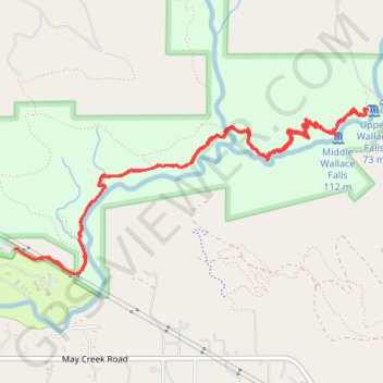
Wallace Falls via Woody Trail in Wallace Falls State Park
Hiking the Wallace Falls via Woody Trail is an enchanting experience where you’re surrounded by towering old-growth trees and the soothing sounds of cascading water. The trail offers several breathtaking viewpoints, with the stunning Middle Falls being a must-see highlight that captures the essence of the park's beauty. Whether you're with family or friends, this well-maintained route provides a perfect mix of adventure and tranquility, making it a fantastic choice for a day in nature. #Hiking #River #Waterfall #Forest #Nature
- Distance: 5.3 mi
- Elevation gain: 1,407 ft
- Maximum elevation: 1,535 ft
- Elevation loss: 1,414 ft
- Minimum elevation: 341 ft
- Moving time: 2 h 22 m
- Moving speed: 2.2 mph
- Maximum speed: 8.5 mph
- Total time: 3 h 1 m
- Global speed: 1.7 mph
Interactive trail map
Make a donation
Gear up for your next adventure:
As an Amazon Associate, this site earns from qualifying purchases at no extra cost to you.
Trail profile
- Distance: 5.3 mi
- Elevation gain: 1,407 ft
- Maximum elevation: 1,535 ft
- Elevation loss: 1,414 ft
- Minimum elevation: 341 ft
- Moving time: 2 h 22 m
- Moving speed: 2.2 mph
- Maximum speed: 8.5 mph
- Total time: 3 h 1 m
- Global speed: 1.7 mph
Make a donation
Gear up for your next adventure:
As an Amazon Associate, this site earns from qualifying purchases at no extra cost to you.
About this trail
Name: Wallace Falls via Woody Trail in Wallace Falls State Park trail, distance, elevation, map, profile, GPS track
Start: Woody Trail, Snohomish County, Washington, 98251, United States (47.86689 -121.67734)
End: Woody Trail, Snohomish County, Washington, 98251, United States (47.86700 -121.67777)
Coordinates: 47.86552 -121.67780 47.87534 -121.64646
Topography: Snohomish County topographic map, elevation, terrain
Make a donation
Gear up for your next adventure:
As an Amazon Associate, this site earns from qualifying purchases at no extra cost to you.
Other hiking, mountain biking, running and outdoor activity trails
Click on a trail to view its statistics, map and profile.
Wallace Falls via Woody Trail in Wallace Falls State Park
United States > Washington > Snohomish County
The Wallace Falls via Woody Trail offers a scenic and rewarding hike with multiple waterfall views along the way. The trail winds through lush forest, alongside the Wallace River, with bridges and benches for resting while soaking in the peaceful atmosphere. While the Middle Falls viewpoint is considered the…
Distance: 5.0 mi • Elevation gain: 1,663 ft • Maximum elevation: 1,699 ft
Northern part of the Pacific Crest Trail (PCT)
United States > Oregon > Klamath County
Hike on the Pacific Crest National Scenic Trail from Crater Lake to Canada Border through Oregon and Washington along the Sierra Nevada and Cascade mountain ranges. #Hiking #Mountain #SierraNevada #Cascade #Nature #Forest #Park #PCT
Distance: 744.6 mi • Elevation gain: 145,367 ft • Maximum elevation: 7,569 ft