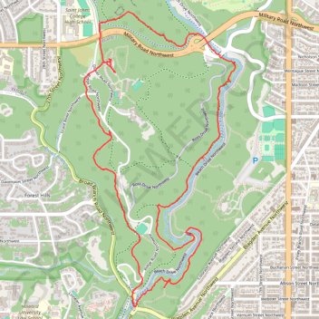
Fort de Russy, Rock Creek and Pulpit Rock Loop via Valley Trail and Western Ridge Trail in Rock Creek Park and Piney Branch Parkway
The loop hike along Fort DeRussy, Rock Creek, and Pulpit Rock offers a blend of historical intrigue and natural beauty. As you traverse the Valley Trail and Western Ridge Trail, you’ll encounter diverse wildlife, vibrant foliage, and the soothing sounds of Rock Creek, which meanders through the park. The elevated views from Pulpit Rock provide a rewarding perspective of the surrounding landscape, making it a fulfilling experience for nature lovers and history enthusiasts alike. #Hiking #Loop #River #Rock #Forest #Nature
- Distance: 4.9 mi
- Elevation gain: 541 ft
- Maximum elevation: 335 ft
- Elevation loss: 541 ft
- Minimum elevation: 82 ft
- Moving time: 2 h 9 m
- Moving speed: 2.2 mph
- Maximum speed: 5.1 mph
- Total time: 2 h 38 m
- Global speed: 1.8 mph
Interactive trail map
Trail profile
- Distance: 4.9 mi
- Elevation gain: 541 ft
- Maximum elevation: 335 ft
- Elevation loss: 541 ft
- Minimum elevation: 82 ft
- Moving time: 2 h 9 m
- Moving speed: 2.2 mph
- Maximum speed: 5.1 mph
- Total time: 2 h 38 m
- Global speed: 1.8 mph
About this trail
Name: Fort de Russy, Rock Creek and Pulpit Rock Loop via Valley Trail and Western Ridge Trail in Rock Creek Park and Piney Branch Parkway trail, distance, elevation, map, profile, GPS track
Start: Woodland Trail, Washington, District of Columbia, 20015, United States (38.95913 -77.05130)
End: Woodland Trail, Washington, District of Columbia, 20015, United States (38.95917 -77.05129)
Coordinates: 38.94344 -77.05400 38.96321 -77.04098
Topography: Washington topographic map, elevation, terrain
Other hiking, mountain biking, running and outdoor activity trails
Click on a trail to view its statistics, map and profile.
Rapids Bridge Loop via White Horse Trail and Black Horse Trail in Rock Creek Park and Piney Branch Parkway
The Rapids Bridge Loop is a serene hiking route in Rock Creek Park, showcasing lush deciduous forests and the soothing sounds of Rock Creek's rushing waters. As you traverse the White Horse Trail and Black Horse Trail, you'll encounter the picturesque Rapids Bridge, offering lovely views of the creek and…
Distance: 1.9 mi • Elevation gain: 233 ft • Maximum elevation: 335 ft
Southern Loop via Western Ridge Trail and Valley Trail in Rock Creek Park and Piney Branch Parkway
The Southern Loop via the Western Ridge Trail and Valley Trail offers a peaceful retreat from urban life, characterized by lush forests and scenic creek views. Hikers can enjoy diverse terrain, from rocky paths to smoother bridle trails, while encountering wildlife and historical features such as Boulder…
Distance: 5.8 mi • Elevation gain: 669 ft • Maximum elevation: 338 ft
Boulder Bridge Loop via Valley Trail and Western Ridge Trail in Rock Creek Park and Piney Branch Parkway
The Boulder Bridge Loop offers a scenic hiking experience that combines wooded trails and picturesque views of Rock Creek, along with the historic Boulder Bridge built in 1902. This route provides an engaging blend of nature and history, suitable for both casual walkers and seasoned hikers. #Hiking #Loop…
Distance: 3.1 mi • Elevation gain: 318 ft • Maximum elevation: 338 ft
Rock Creek Park Loop via Western Ridge Trail and Valley Trail
The Rock Creek Park Loop via the Western Ridge Trail and Valley Trail offers a scenic blend of lush woodlands, meandering creeks, and diverse wildlife, providing a refreshing escape into nature while still being conveniently accessible from the city. #Hiking #Loop #River #Forest #Nature
Distance: 10.3 mi • Elevation gain: 961 ft • Maximum elevation: 331 ft
Hillwood Estate Gardens
Distance: 0.6 mi • Elevation gain: 85 ft • Maximum elevation: 223 ft