
Hillwood Estate Gardens
- Distance: 0.6 mi
- Elevation gain: 85 ft
- Maximum elevation: 223 ft
- Elevation loss: 56 ft
- Minimum elevation: 184 ft
- Moving time: 23 m 26 s
- Moving speed: 1.6 mph
- Maximum speed: 3.2 mph
- Total time: 25 m 59 s
- Global speed: 1.4 mph
Interactive trail map
Trail profile
- Distance: 0.6 mi
- Elevation gain: 85 ft
- Maximum elevation: 223 ft
- Elevation loss: 56 ft
- Minimum elevation: 184 ft
- Moving time: 23 m 26 s
- Moving speed: 1.6 mph
- Maximum speed: 3.2 mph
- Total time: 25 m 59 s
- Global speed: 1.4 mph
About this trail
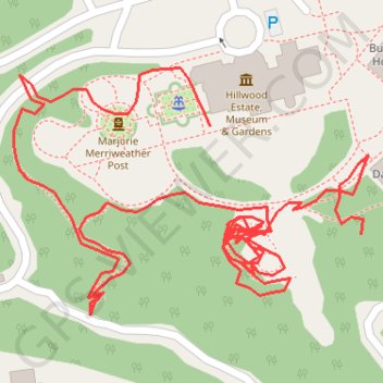
Name: Hillwood Estate Gardens trail, distance, elevation, map, profile, GPS track
Coordinates: 38.94269 -77.05387 38.94370 -77.05201
Topography: Washington topographic map, elevation, terrain
Other hiking, mountain biking, running and outdoor activity trails
Click on a trail to view its statistics, map and profile.
Southern Loop via Western Ridge Trail and Valley Trail in Rock Creek Park and Piney Branch Parkway
The Southern Loop via the Western Ridge Trail and Valley Trail offers a peaceful retreat from urban life, characterized by lush forests and scenic creek views. Hikers can enjoy diverse terrain, from rocky paths to smoother bridle trails, while encountering wildlife and historical features such as Boulder…
Distance: 5.8 mi • Elevation gain: 669 ft • Maximum elevation: 338 ft
Fort de Russy, Rock Creek and Pulpit Rock Loop via Valley Trail and Western Ridge Trail in Rock Creek Park and Piney Branch Parkway
The loop hike along Fort DeRussy, Rock Creek, and Pulpit Rock offers a blend of historical intrigue and natural beauty. As you traverse the Valley Trail and Western Ridge Trail, you’ll encounter diverse wildlife, vibrant foliage, and the soothing sounds of Rock Creek, which meanders through the park. The…
Distance: 4.9 mi • Elevation gain: 541 ft • Maximum elevation: 335 ft
Rock Creek Park Loop via Western Ridge Trail and Valley Trail
The Rock Creek Park Loop via the Western Ridge Trail and Valley Trail offers a scenic blend of lush woodlands, meandering creeks, and diverse wildlife, providing a refreshing escape into nature while still being conveniently accessible from the city. #Hiking #Loop #River #Forest #Nature
Distance: 10.3 mi • Elevation gain: 961 ft • Maximum elevation: 331 ft