Rockway Conservation Area Loop Hike
- Distance: 4.3 mi
- Elevation gain: 495 ft
- Maximum elevation: 492 ft
- Elevation loss: 499 ft
- Minimum elevation: 289 ft
- Moving time: 1 h 50 m
- Moving speed: 2.3 mph
- Maximum speed: 3.9 mph
- Total time: 2 h 16 m
- Global speed: 1.9 mph
Interactive trail map
Trail profile
- Distance: 4.3 mi
- Elevation gain: 495 ft
- Maximum elevation: 492 ft
- Elevation loss: 499 ft
- Minimum elevation: 289 ft
- Moving time: 1 h 50 m
- Moving speed: 2.3 mph
- Maximum speed: 3.9 mph
- Total time: 2 h 16 m
- Global speed: 1.9 mph
About this trail
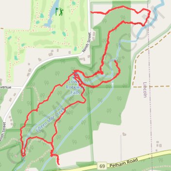
Name: Rockway Conservation Area Loop Hike trail, distance, elevation, map, profile, GPS track
Coordinates: 43.11185 -79.32263 43.12249 -79.31067
Other hiking, mountain biking, running and outdoor activity trails
Click on a trail to view its statistics, map and profile.
Niagara Falls - Hamilton
Canada > Ontario > Niagara Region > Niagara Falls
#Bike
Distance: 52.3 mi • Elevation gain: 1,762 ft • Maximum elevation: 686 ft