徑口坑 營盤 泰亨坑
Hong Kong Hike
- Distance: 10.4 mi
- Elevation gain: 3,445 ft
- Maximum elevation: 1,598 ft
- Elevation loss: 3,593 ft
- Minimum elevation: 10 ft
- Moving time: 4 h 21 m
- Moving speed: 2.4 mph
- Maximum speed: 18.4 mph
- Total time: 7 h 27 m
- Global speed: 1.4 mph
Interactive trail map
Trail profile
- Distance: 10.4 mi
- Elevation gain: 3,445 ft
- Maximum elevation: 1,598 ft
- Elevation loss: 3,593 ft
- Minimum elevation: 10 ft
- Moving time: 4 h 21 m
- Moving speed: 2.4 mph
- Maximum speed: 18.4 mph
- Total time: 7 h 27 m
- Global speed: 1.4 mph
About this trail
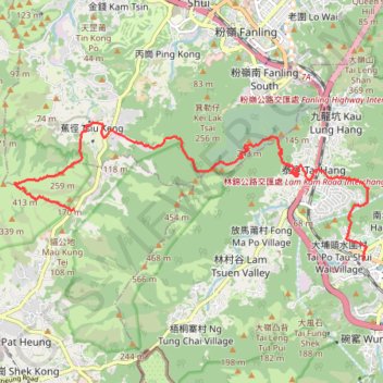
Name: 徑口坑 營盤 泰亨坑 trail, distance, elevation, map, profile, GPS track
Coordinates: 22.45172 114.09142 22.47745 114.16303
Other hiking, mountain biking, running and outdoor activity trails
Click on a trail to view its statistics, map and profile.
Wilson Trail Full Route
China > Hong Kong > Hong Kong Island
Distance: 50.5 mi • Elevation gain: 14,534 ft • Maximum elevation: 2,011 ft
石塘左左 担水徑坑
China > Hong Kong > Yuen Long District > Sheung Che
Hike
Distance: 3.7 mi • Elevation gain: 1,437 ft • Maximum elevation: 1,555 ft
Cloudy Hill
China > Hong Kong > North District > Kwan Tei Tsuen > Po Kak Tsai
Distance: 5.6 mi • Elevation gain: 1,539 ft • Maximum elevation: 1,368 ft
Kai Kung Leng east
China > Hong Kong > Yuen Long District > Sheung Che
Distance: 2.1 mi • Elevation gain: 1,204 ft • Maximum elevation: 1,299 ft