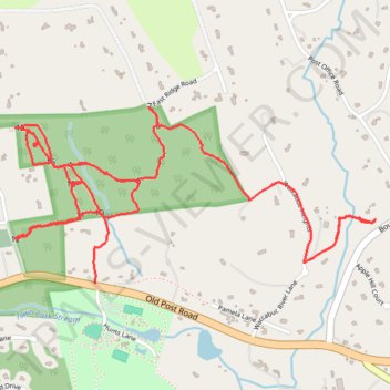
Old Field Preserve Trails
- Distance: 3.9 mi
- Elevation gain: 440 ft
- Maximum elevation: 686 ft
- Elevation loss: 351 ft
- Minimum elevation: 456 ft
- Moving time: 1 h 31 m
- Moving speed: 2.6 mph
- Maximum speed: 5.4 mph
- Total time: 1 h 38 m
- Global speed: 2.4 mph
Interactive trail map
Trail profile
- Distance: 3.9 mi
- Elevation gain: 440 ft
- Maximum elevation: 686 ft
- Elevation loss: 351 ft
- Minimum elevation: 456 ft
- Moving time: 1 h 31 m
- Moving speed: 2.6 mph
- Maximum speed: 5.4 mph
- Total time: 1 h 38 m
- Global speed: 2.4 mph
About this trail
Name: Old Field Preserve Trails trail, distance, elevation, map, profile, GPS track
Coordinates: 41.27757 -73.59305 41.28440 -73.57454
Topography: Westchester County topographic map, elevation, terrain
Other hiking, mountain biking, running and outdoor activity trails
Click on a trail to view its statistics, map and profile.