Make a donation
Gear up for your next adventure:
As an Amazon Associate, this site earns from qualifying purchases at no extra cost to you.
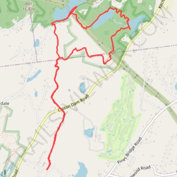
Three Lakes Loop (Teatown Lake, Vernay Lake and Shadow Lake) via Briarcliff-Peekskill Trail
Description:
- Distance: 5.8 mi
- Elevation gain: 689 ft
- Maximum elevation: 597 ft
- Elevation loss: 689 ft
- Minimum elevation: 335 ft
- Moving time: 1 h 56 m
- Moving speed: 3.0 mph
- Maximum speed: 6.2 mph
- Total time: 1 h 59 m
- Global speed: 2.9 mph
Interactive trail map
Make a donation
Gear up for your next adventure:
As an Amazon Associate, this site earns from qualifying purchases at no extra cost to you.
Trail profile
- Distance: 5.8 mi
- Elevation gain: 689 ft
- Maximum elevation: 597 ft
- Elevation loss: 689 ft
- Minimum elevation: 335 ft
- Moving time: 1 h 56 m
- Moving speed: 3.0 mph
- Maximum speed: 6.2 mph
- Total time: 1 h 59 m
- Global speed: 2.9 mph
Make a donation
Gear up for your next adventure:
As an Amazon Associate, this site earns from qualifying purchases at no extra cost to you.
About this trail
Name: Three Lakes Loop (Teatown Lake, Vernay Lake and Shadow Lake) via Briarcliff-Peekskill Trail trail, distance, elevation, map, profile, GPS track
Coordinates: 41.18749 -73.83620 41.21077 -73.82047
Topography: Westchester County topographic map, elevation, terrain
Make a donation
Gear up for your next adventure:
As an Amazon Associate, this site earns from qualifying purchases at no extra cost to you.
Other hiking, mountain biking, running and outdoor activity trails
Click on a trail to view its statistics, map and profile.
Teatown Lake Reservation: Overlook Trail, Hidden Valley Loop and Phenology Trail
United States > New York > Westchester County > Town of Yorktown > Glendale
Distance: 4.3 mi • Elevation gain: 515 ft • Maximum elevation: 587 ft