Lake Shore Loop Trail
- Distance: 5.5 mi
- Elevation gain: 446 ft
- Maximum elevation: 873 ft
- Elevation loss: 446 ft
- Minimum elevation: 764 ft
- Moving time: 1 h 6 m
- Moving speed: 5.0 mph
- Maximum speed: 8.4 mph
- Total time: 1 h 6 m
- Global speed: 5.0 mph
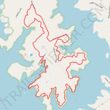
Interactive trail map
Trail profile
- Distance: 5.5 mi
- Elevation gain: 446 ft
- Maximum elevation: 873 ft
- Elevation loss: 446 ft
- Minimum elevation: 764 ft
- Moving time: 1 h 6 m
- Moving speed: 5.0 mph
- Maximum speed: 8.4 mph
- Total time: 1 h 6 m
- Global speed: 5.0 mph
About this trail
Name: Lake Shore Loop Trail trail, distance, elevation, map, profile, GPS track
Start: Lake Shore Trail (southern half), Iredell County, North Carolina, United States (35.64944 -80.94411)
End: Shortleaf Drive, Iredell County, North Carolina, United States (35.64949 -80.94415)
Coordinates: 35.64173 -80.94783 35.65767 -80.93586
Topography: Iredell County topographic map, elevation, terrain
Other hiking, mountain biking, running and outdoor activity trails
Click on a trail to view its statistics, map and profile.
Lake Shore Loop Trail in Lake Norman State Park
United States > North Carolina > Iredell County
Distance: 7.7 mi • Elevation gain: 686 ft • Maximum elevation: 866 ft
Lake Norman State Park Hike
United States > North Carolina > Iredell County
Distance: 3.5 mi • Elevation gain: 220 ft • Maximum elevation: 840 ft
Lake Shore Loop Trail
United States > North Carolina > Iredell County
Distance: 6.2 mi • Elevation gain: 522 ft • Maximum elevation: 866 ft