Gem Lake Trail in Rocky Mountain National Park
The Gem Lake Trail offers an enjoyable hike through varied terrain, taking visitors past grassy meadows, shaded forests, and rocky outcroppings. Once at Gem Lake, hikers are treated to panoramic views of the surrounding peaks, including Lumpy Ridge's granite formations, and can explore the lake's tranquil waters framed by large boulders. The route provides numerous opportunities for exploration, from scrambling up nearby granite domes to enjoying the vistas of Estes Valley and the snow-capped Rockies. #Hiking #Mountain #Lake #Forest #Nature
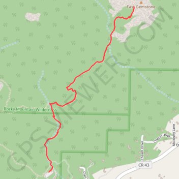
- Distance: 2.9 mi
- Elevation gain: 997 ft
- Maximum elevation: 8,832 ft
- Elevation loss: 997 ft
- Minimum elevation: 7,851 ft
Interactive trail map
Trail profile
- Distance: 2.9 mi
- Elevation gain: 997 ft
- Maximum elevation: 8,832 ft
- Elevation loss: 997 ft
- Minimum elevation: 7,851 ft
About this trail
Name: Gem Lake Trail in Rocky Mountain National Park trail, distance, elevation, map, profile, GPS track
Coordinates: 40.39660 -105.51310 40.40987 -105.50372
Topography: Larimer County topographic map, elevation, terrain
Other hiking, mountain biking, running and outdoor activity trails
Click on a trail to view its statistics, map and profile.