Make a donation
Gear up for your next adventure:
As an Amazon Associate, this site earns from qualifying purchases at no extra cost to you.
Gem Lake
Interactive trail map
Make a donation
Gear up for your next adventure:
As an Amazon Associate, this site earns from qualifying purchases at no extra cost to you.
Trail profile
- Distance: 3.2 mi
- Elevation gain: 1,060 ft
- Maximum elevation: 8,898 ft
- Elevation loss: 1,063 ft
- Minimum elevation: 7,851 ft
Make a donation
Gear up for your next adventure:
As an Amazon Associate, this site earns from qualifying purchases at no extra cost to you.
About this trail
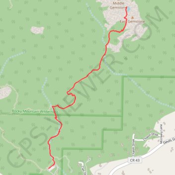
Name: Gem Lake trail, distance, elevation, map, profile, GPS track
Coordinates: 40.39645 -105.51310 40.41123 -105.50364
Topography: Larimer County topographic map, elevation, terrain
Make a donation
Gear up for your next adventure:
As an Amazon Associate, this site earns from qualifying purchases at no extra cost to you.
Other hiking, mountain biking, running and outdoor activity trails
Click on a trail to view its statistics, map and profile.
Gem Lake Trail in Rocky Mountain National Park
United States > Colorado > Larimer County
The Gem Lake Trail offers an enjoyable hike through varied terrain, taking visitors past grassy meadows, shaded forests, and rocky outcroppings. Once at Gem Lake, hikers are treated to panoramic views of the surrounding peaks, including Lumpy Ridge's granite formations, and can explore the lake's tranquil…
Distance: 2.9 mi • Elevation gain: 997 ft • Maximum elevation: 8,832 ft