Mount Pisgah via South Trail and Pulpit Rock in Willoughby State Forest
The hike to Mount Pisgah is a rewarding journey with iconic views. As you ascend, Pulpit Rock provides a dramatic viewpoint perched hundreds of feet above the stunning Lake Willoughby, framed by the rugged cliffs of nearby Mount Hor. The summit reveals panoramic vistas that stretch across the Northeast Kingdom, extending into New Hampshire and even glimpses of Quebec’s wilderness, making the effort worthwhile for a variety of hiking skill levels. #Hiking #Mountain #Lake #Forest #Nature
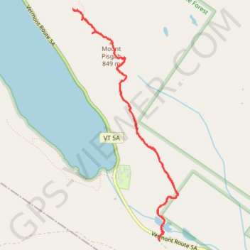
- Distance: 4.6 mi
- Elevation gain: 2,329 ft
- Maximum elevation: 2,726 ft
- Elevation loss: 2,306 ft
- Minimum elevation: 1,280 ft
Interactive trail map
Trail profile
- Distance: 4.6 mi
- Elevation gain: 2,329 ft
- Maximum elevation: 2,726 ft
- Elevation loss: 2,306 ft
- Minimum elevation: 1,280 ft
About this trail
Name: Mount Pisgah via South Trail and Pulpit Rock in Willoughby State Forest trail, distance, elevation, map, profile, GPS track
Start: South Trail, Westmore, Orleans County, Vermont, United States (44.71084 -72.02362)
Coordinates: 44.71025 -72.03606 44.73289 -72.02143
Topography: Orleans County topographic map, elevation, terrain
Other hiking, mountain biking, running and outdoor activity trails
Click on a trail to view its statistics, map and profile.