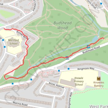
Budshead Wood
- Distance: 0.7 mi
- Elevation gain: 30 ft
- Maximum elevation: 207 ft
- Elevation loss: 138 ft
- Minimum elevation: 66 ft
- Moving time: 18 m 29 s
- Moving speed: 2.2 mph
- Maximum speed: 3.6 mph
- Total time: 18 m 29 s
- Global speed: 2.2 mph
Interactive trail map
Trail profile
- Distance: 0.7 mi
- Elevation gain: 30 ft
- Maximum elevation: 207 ft
- Elevation loss: 138 ft
- Minimum elevation: 66 ft
- Moving time: 18 m 29 s
- Moving speed: 2.2 mph
- Maximum speed: 3.6 mph
- Total time: 18 m 29 s
- Global speed: 2.2 mph
About this trail
Name: Budshead Wood trail, distance, elevation, map, profile, GPS track
End: Budshead Road, West Park, Plymouth, England, PL5 3RL, United Kingdom (50.41808 -4.16344)
Coordinates: 50.41603 -4.17126 50.41855 -4.16344
Other hiking, mountain biking, running and outdoor activity trails
Click on a trail to view its statistics, map and profile.
Woodland Fort paths
United Kingdom > England > Plymouth
Distance: 3.3 mi • Elevation gain: 318 ft • Maximum elevation: 269 ft
Budshead wood
United Kingdom > England > Plymouth
Distance: 2.7 mi • Elevation gain: 164 ft • Maximum elevation: 112 ft
Budshead Wood
United Kingdom > England > Plymouth
Distance: 1.8 mi • Elevation gain: 220 ft • Maximum elevation: 184 ft
Budshead wood
United Kingdom > England > Plymouth
Distance: 0.8 mi • Elevation gain: 102 ft • Maximum elevation: 223 ft