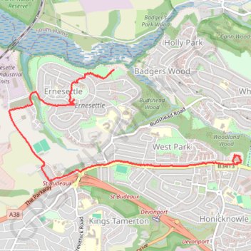
Woodland Fort paths
- Distance: 3.3 mi
- Elevation gain: 318 ft
- Maximum elevation: 269 ft
- Elevation loss: 154 ft
- Minimum elevation: 36 ft
- Moving time: 58 m 58 s
- Moving speed: 3.3 mph
- Maximum speed: 29.1 mph
- Total time: 1 h 11 m
- Global speed: 2.7 mph
Interactive trail map
Trail profile
- Distance: 3.3 mi
- Elevation gain: 318 ft
- Maximum elevation: 269 ft
- Elevation loss: 154 ft
- Minimum elevation: 36 ft
- Moving time: 58 m 58 s
- Moving speed: 3.3 mph
- Maximum speed: 29.1 mph
- Total time: 1 h 11 m
- Global speed: 2.7 mph
About this trail
Name: Woodland Fort paths trail, distance, elevation, map, profile, GPS track
Coordinates: 50.41147 -4.18761 50.42186 -4.15349
Other hiking, mountain biking, running and outdoor activity trails
Click on a trail to view its statistics, map and profile.
Woodland Woods
United Kingdom > England > Plymouth
Distance: 1.8 mi • Elevation gain: 233 ft • Maximum elevation: 262 ft
Budshead wood
United Kingdom > England > Plymouth
Distance: 2.7 mi • Elevation gain: 164 ft • Maximum elevation: 112 ft
Budshead Wood
United Kingdom > England > Plymouth
Distance: 1.8 mi • Elevation gain: 220 ft • Maximum elevation: 184 ft
Budshead wood
United Kingdom > England > Plymouth
Distance: 0.8 mi • Elevation gain: 102 ft • Maximum elevation: 223 ft
Budshead Wood
United Kingdom > England > Plymouth
Distance: 0.7 mi • Elevation gain: 30 ft • Maximum elevation: 207 ft