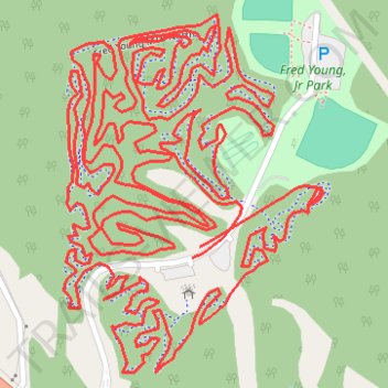
Fred Young MTB Whole Route
- Distance: 6.3 mi
- Elevation gain: 476 ft
- Maximum elevation: 509 ft
- Elevation loss: 479 ft
- Minimum elevation: 433 ft
- Moving time: 58 m 42 s
- Moving speed: 6.5 mph
- Maximum speed: 14.2 mph
- Total time: 1 h 1 m
- Global speed: 6.1 mph
Interactive trail map
Trail profile
- Distance: 6.3 mi
- Elevation gain: 476 ft
- Maximum elevation: 509 ft
- Elevation loss: 479 ft
- Minimum elevation: 433 ft
- Moving time: 58 m 42 s
- Moving speed: 6.5 mph
- Maximum speed: 14.2 mph
- Total time: 1 h 1 m
- Global speed: 6.1 mph
About this trail
Name: Fred Young MTB Whole Route trail, distance, elevation, map, profile, GPS track
Start: Madison County, West Tennessee, Tennessee, United States (35.52513 -88.76434)
End: Madison County, West Tennessee, Tennessee, United States (35.52496 -88.76449)
Coordinates: 35.52308 -88.76708 35.52892 -88.76186
Topography: Madison County topographic map, elevation, terrain
Other hiking, mountain biking, running and outdoor activity trails
Click on a trail to view its statistics, map and profile.
Fred Young, Jr Park South MTB
United States > Tennessee > Madison County
Distance: 4.6 mi • Elevation gain: 312 ft • Maximum elevation: 509 ft
Gmaps Pedometer Route
United States > Kentucky > Fulton County > Hickman
Distance: 312.5 mi • Elevation gain: 13,793 ft • Maximum elevation: 1,942 ft