Make a donation
Gear up for your next adventure:
As an Amazon Associate, this site earns from qualifying purchases at no extra cost to you.
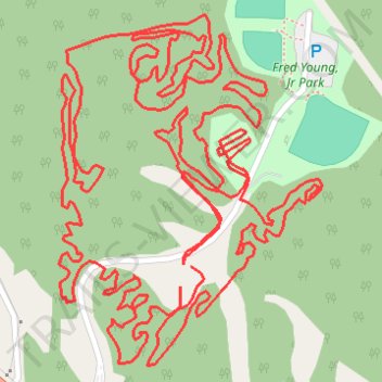
Fred Young, Jr Park South MTB
- Distance: 4.6 mi
- Elevation gain: 312 ft
- Maximum elevation: 509 ft
- Elevation loss: 315 ft
- Minimum elevation: 433 ft
- Moving time: 55 m 54 s
- Moving speed: 4.9 mph
- Maximum speed: 15.7 mph
- Total time: 1 h 5 m
- Global speed: 4.2 mph
Interactive trail map
Make a donation
Gear up for your next adventure:
As an Amazon Associate, this site earns from qualifying purchases at no extra cost to you.
Trail profile
- Distance: 4.6 mi
- Elevation gain: 312 ft
- Maximum elevation: 509 ft
- Elevation loss: 315 ft
- Minimum elevation: 433 ft
- Moving time: 55 m 54 s
- Moving speed: 4.9 mph
- Maximum speed: 15.7 mph
- Total time: 1 h 5 m
- Global speed: 4.2 mph
Make a donation
Gear up for your next adventure:
As an Amazon Associate, this site earns from qualifying purchases at no extra cost to you.
About this trail
Name: Fred Young, Jr Park South MTB trail, distance, elevation, map, profile, GPS track
Start: Madison County, West Tennessee, Tennessee, United States (35.52475 -88.76439)
End: Madison County, West Tennessee, Tennessee, United States (35.52442 -88.76460)
Coordinates: 35.52311 -88.76705 35.52890 -88.76175
Topography: Madison County topographic map, elevation, terrain
Make a donation
Gear up for your next adventure:
As an Amazon Associate, this site earns from qualifying purchases at no extra cost to you.
Other hiking, mountain biking, running and outdoor activity trails
Click on a trail to view its statistics, map and profile.
Fred Young MTB Whole Route
United States > Tennessee > Madison County
Distance: 6.3 mi • Elevation gain: 476 ft • Maximum elevation: 509 ft
Gmaps Pedometer Route
United States > Kentucky > Fulton County > Hickman
Distance: 312.5 mi • Elevation gain: 13,793 ft • Maximum elevation: 1,942 ft