Make a donation
Gear up for your next adventure:
As an Amazon Associate, this site earns from qualifying purchases at no extra cost to you.
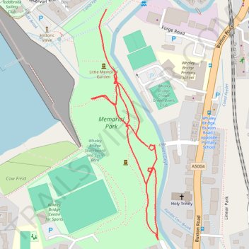
Memorial park
- Distance: 0.7 mi
- Elevation gain: 56 ft
- Maximum elevation: 607 ft
- Elevation loss: 46 ft
- Minimum elevation: 561 ft
- Moving time: 18 m 9 s
- Moving speed: 2.4 mph
- Maximum speed: 4.6 mph
- Total time: 18 m 9 s
- Global speed: 2.4 mph
Interactive trail map
Make a donation
Gear up for your next adventure:
As an Amazon Associate, this site earns from qualifying purchases at no extra cost to you.
Trail profile
- Distance: 0.7 mi
- Elevation gain: 56 ft
- Maximum elevation: 607 ft
- Elevation loss: 46 ft
- Minimum elevation: 561 ft
- Moving time: 18 m 9 s
- Moving speed: 2.4 mph
- Maximum speed: 4.6 mph
- Total time: 18 m 9 s
- Global speed: 2.4 mph
Make a donation
Gear up for your next adventure:
As an Amazon Associate, this site earns from qualifying purchases at no extra cost to you.
About this trail
Name: Memorial park trail, distance, elevation, map, profile, GPS track
Coordinates: 53.32393 -1.98793 53.32759 -1.98614
Make a donation
Gear up for your next adventure:
As an Amazon Associate, this site earns from qualifying purchases at no extra cost to you.
Other hiking, mountain biking, running and outdoor activity trails
Click on a trail to view its statistics, map and profile.
Memorial Park loop
United Kingdom > England > Derbyshire > High Peak > Whaley Bridge > Buxworth
Distance: 1.5 mi • Elevation gain: 171 ft • Maximum elevation: 636 ft
Memorial Park
United Kingdom > England > Derbyshire > High Peak > Whaley Bridge > Buxworth
Distance: 1.0 mi • Elevation gain: 98 ft • Maximum elevation: 617 ft