Memorial Park loop
- Distance: 1.5 mi
- Elevation gain: 171 ft
- Maximum elevation: 636 ft
- Elevation loss: 171 ft
- Minimum elevation: 564 ft
- Moving time: 35 m 4 s
- Moving speed: 2.6 mph
- Maximum speed: 4.2 mph
- Total time: 36 m 36 s
- Global speed: 2.5 mph
Interactive trail map
Trail profile
- Distance: 1.5 mi
- Elevation gain: 171 ft
- Maximum elevation: 636 ft
- Elevation loss: 171 ft
- Minimum elevation: 564 ft
- Moving time: 35 m 4 s
- Moving speed: 2.6 mph
- Maximum speed: 4.2 mph
- Total time: 36 m 36 s
- Global speed: 2.5 mph
About this trail
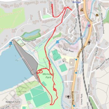
Name: Memorial Park loop trail, distance, elevation, map, profile, GPS track
Coordinates: 53.32415 -1.98843 53.32979 -1.98516
Other hiking, mountain biking, running and outdoor activity trails
Click on a trail to view its statistics, map and profile.
Memorial Park
United Kingdom > England > Derbyshire > High Peak > Whaley Bridge > Buxworth
Distance: 1.0 mi • Elevation gain: 98 ft • Maximum elevation: 617 ft
Memorial park
United Kingdom > England > Derbyshire > High Peak > Whaley Bridge > Buxworth
Distance: 0.7 mi • Elevation gain: 56 ft • Maximum elevation: 607 ft