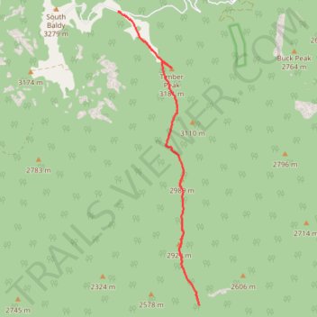
Timber Peak Trail
- Distance: 5.3 mi
- Elevation gain: 1,161 ft
- Maximum elevation: 10,390 ft
- Elevation loss: 2,306 ft
- Minimum elevation: 8,691 ft
- Moving time: 3 h 24 m
- Moving speed: 1.6 mph
- Maximum speed: 3.4 mph
- Total time: 4 h 50 m
- Global speed: 1.1 mph
Interactive trail map
Trail profile
- Distance: 5.3 mi
- Elevation gain: 1,161 ft
- Maximum elevation: 10,390 ft
- Elevation loss: 2,306 ft
- Minimum elevation: 8,691 ft
- Moving time: 3 h 24 m
- Moving speed: 1.6 mph
- Maximum speed: 3.4 mph
- Total time: 4 h 50 m
- Global speed: 1.1 mph
About this trail
Name: Timber Peak Trail trail, distance, elevation, map, profile, GPS track
Start: Timber Peak Trail, Socorro County, New Mexico, United States (33.99038 -107.17302)
End: Timber Peak Trail, Socorro County, New Mexico, United States (33.93177 -107.15348)
Coordinates: 33.93177 -107.17302 33.99038 -107.15348
Topography: Socorro County topographic map, elevation, terrain
Other hiking, mountain biking, running and outdoor activity trails
Click on a trail to view its statistics, map and profile.
Sawmill Canyon
United States > New Mexico > Socorro County
Distance: 7.3 mi • Elevation gain: 3,261 ft • Maximum elevation: 9,925 ft