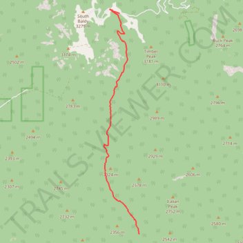
Sawmill Canyon
- Distance: 7.3 mi
- Elevation gain: 3,261 ft
- Maximum elevation: 9,925 ft
- Elevation loss: 167 ft
- Minimum elevation: 6,732 ft
- Moving time: 5 h 23 m
- Moving speed: 1.3 mph
- Maximum speed: 3.7 mph
- Total time: 20 h 9 m
- Global speed: 0.4 mph
Interactive trail map
Trail profile
- Distance: 7.3 mi
- Elevation gain: 3,261 ft
- Maximum elevation: 9,925 ft
- Elevation loss: 167 ft
- Minimum elevation: 6,732 ft
- Moving time: 5 h 23 m
- Moving speed: 1.3 mph
- Maximum speed: 3.7 mph
- Total time: 20 h 9 m
- Global speed: 0.4 mph
About this trail
Name: Sawmill Canyon trail, distance, elevation, map, profile, GPS track
Start: West Fork Trail, Socorro County, New Mexico, United States (33.91523 -107.16491)
End: Timber Peak Trail, Socorro County, New Mexico, United States (33.99037 -107.17302)
Coordinates: 33.91523 -107.17938 33.99183 -107.16487
Topography: Socorro County topographic map, elevation, terrain
Other hiking, mountain biking, running and outdoor activity trails
Click on a trail to view its statistics, map and profile.
Timber Peak Trail
United States > New Mexico > Socorro County
Distance: 5.3 mi • Elevation gain: 1,161 ft • Maximum elevation: 10,390 ft