Make a donation
Gear up for your next adventure:
As an Amazon Associate, this site earns from qualifying purchases at no extra cost to you.
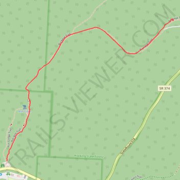
GoMap__2026_04_11__17_01_07
- Distance: 1.1 mi
- Elevation gain: 10 ft
- Maximum elevation: 1,063 ft
- Elevation loss: 256 ft
- Minimum elevation: 814 ft
- Moving time: 23 m 26 s
- Moving speed: 2.8 mph
- Maximum speed: 12.0 mph
- Total time: 24 m 1 s
- Global speed: 2.7 mph
Interactive trail map
Make a donation
Gear up for your next adventure:
As an Amazon Associate, this site earns from qualifying purchases at no extra cost to you.
Trail profile
- Distance: 1.1 mi
- Elevation gain: 10 ft
- Maximum elevation: 1,063 ft
- Elevation loss: 256 ft
- Minimum elevation: 814 ft
- Moving time: 23 m 26 s
- Moving speed: 2.8 mph
- Maximum speed: 12.0 mph
- Total time: 24 m 1 s
- Global speed: 2.7 mph
Make a donation
Gear up for your next adventure:
As an Amazon Associate, this site earns from qualifying purchases at no extra cost to you.
About this trail
Name: GoMap__2026_04_11__17_01_07 trail, distance, elevation, map, profile, GPS track
Start: Buckeye Trail, Benton Township, Hocking County, Ohio, United States (39.40411 -82.53386)
End: Ash Gorge Trail, Benton Township, Hocking County, Ohio, United States (39.39640 -82.54562)
Coordinates: 39.39640 -82.54562 39.40419 -82.53378
Topography: Hocking County topographic map, elevation, terrain
Make a donation
Gear up for your next adventure:
As an Amazon Associate, this site earns from qualifying purchases at no extra cost to you.
Other hiking, mountain biking, running and outdoor activity trails
Click on a trail to view its statistics, map and profile.
GoMap__2026_04_11__17_31_37
United States > Ohio > Hocking County
Distance: 13.6 mi • Elevation gain: 778 ft • Maximum elevation: 840 ft
GoMap__2026_04_11__14_17_52
United States > Ohio > Hocking County
Distance: 0.7 mi • Elevation gain: 125 ft • Maximum elevation: 1,030 ft
GoMap__2026_04_11__14_35_15
United States > Ohio > Hocking County
Distance: 0.4 mi • Elevation gain: 66 ft • Maximum elevation: 1,083 ft