Make a donation
Gear up for your next adventure:
As an Amazon Associate, this site earns from qualifying purchases at no extra cost to you.
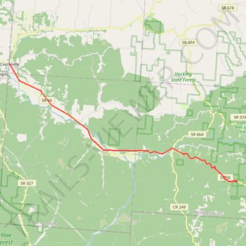
GoMap__2026_04_11__17_31_37
- Distance: 13.6 mi
- Elevation gain: 778 ft
- Maximum elevation: 840 ft
- Elevation loss: 853 ft
- Minimum elevation: 676 ft
- Moving time: 19 m 56 s
- Moving speed: 41.0 mph
- Maximum speed: 55.3 mph
- Total time: 20 m 35 s
- Global speed: 39.7 mph
Interactive trail map
Make a donation
Gear up for your next adventure:
As an Amazon Associate, this site earns from qualifying purchases at no extra cost to you.
Trail profile
- Distance: 13.6 mi
- Elevation gain: 778 ft
- Maximum elevation: 840 ft
- Elevation loss: 853 ft
- Minimum elevation: 676 ft
- Moving time: 19 m 56 s
- Moving speed: 41.0 mph
- Maximum speed: 55.3 mph
- Total time: 20 m 35 s
- Global speed: 39.7 mph
Make a donation
Gear up for your next adventure:
As an Amazon Associate, this site earns from qualifying purchases at no extra cost to you.
About this trail
Name: GoMap__2026_04_11__17_31_37 trail, distance, elevation, map, profile, GPS track
Coordinates: 39.39508 -82.73976 39.47346 -82.54421
Topography: Hocking County topographic map, elevation, terrain
Make a donation
Gear up for your next adventure:
As an Amazon Associate, this site earns from qualifying purchases at no extra cost to you.
Other hiking, mountain biking, running and outdoor activity trails
Click on a trail to view its statistics, map and profile.
Gorge Overlook Trail and Buckeye Trail Loop via Old Man's Cave, Whispering Falls, Cedar Falls and Rose Lake
United States > Ohio > Hocking County > Cedar Grove
The Gorge Overlook Trail and Buckeye Trail Loop, starting from Old Man's Cave, offers a scenic journey through Hocking Hills State Park, showcasing its diverse geological features and lush landscapes. Hikers will encounter impressive sandstone cliffs, picturesque waterfalls such as Cedar Falls and Whispering…
Distance: 5.9 mi • Elevation gain: 548 ft • Maximum elevation: 948 ft
Gorge Overlook Trail and Buckeye Trail Loop Hike in Hocking Hills State Park
United States > Ohio > Hocking County > Cedar Grove
The Gorge Overlook Trail and Buckeye Trail Loop in Hocking Hills State Park provide a captivating mix of geological wonders and natural beauty. Hikers will experience stunning sandstone cliffs, cascading waterfalls like Cedar Falls and Whispering Falls, and serene spots like Rose Lake and the lush, forested…
Distance: 5.5 mi • Elevation gain: 515 ft • Maximum elevation: 945 ft
Cedar Falls from Old Man's Cave via Buckeye Trail in Hocking Hills State Park
United States > Ohio > Hocking County > Cedar Grove
The hike from Old Man's Cave to Cedar Falls offers a blend of stunning natural beauty and unique geological features. As you traverse the trail, you'll encounter the towering hemlocks, steep sandstone cliffs, and cascading waters of Cedar Falls, which is particularly impressive after rainfall. The…
Distance: 5.4 mi • Elevation gain: 463 ft • Maximum elevation: 912 ft
Upper Falls to Lower Falls Loop via Gorge Exit Trail and Buckeye Trail in Hocking Hills State Park
United States > Ohio > Hocking County > Cedar Grove
The Upper Falls to Lower Falls Loop in Hocking Hills State Park offers a scenic journey through stunning landscapes characterized by lush greenery, rugged sandstone cliffs, and cascading waterfalls. Along the route, hikers can enjoy the serene beauty of both the Upper and Lower Falls, each presenting a unique…
Distance: 1.2 mi • Elevation gain: 108 ft • Maximum elevation: 922 ft
Make a donation
Gear up for your next adventure:
As an Amazon Associate, this site earns from qualifying purchases at no extra cost to you.
Upper Falls and Lower Falls Loop via Buckeye Trail in Hocking Hills State Park
United States > Ohio > Hocking County > Cedar Grove
Embarking on the Upper Falls to Lower Falls loop via the Buckeye Trail in Hocking Hills State Park offers hikers a journey through captivating natural features. The trail begins at the Upper Falls, leading through the Upper Gorge, past the striking Middle Falls, and culminating at the serene Lower Falls. Along…
Distance: 1.0 mi • Elevation gain: 85 ft • Maximum elevation: 915 ft
Broken Rock Falls
United States > Ohio > Hocking County > Cedar Grove
Hocking Hills trails near the visitor center
Distance: 1.1 mi • Elevation gain: 154 ft • Maximum elevation: 906 ft
GoMap__2026_04_11__17_55_28
United States > Ohio > Hocking County > Laurelville
Distance: 61.8 mi • Elevation gain: 1,736 ft • Maximum elevation: 1,070 ft
GoMap__2026_04_11__17_01_07
United States > Ohio > Hocking County
Distance: 1.1 mi • Elevation gain: 10 ft • Maximum elevation: 1,063 ft
Make a donation
Gear up for your next adventure:
As an Amazon Associate, this site earns from qualifying purchases at no extra cost to you.
GoMap__2026_04_11__14_17_52
United States > Ohio > Hocking County
Distance: 0.7 mi • Elevation gain: 125 ft • Maximum elevation: 1,030 ft