Thank you for supporting this site ❤️
Make a donation
Make a donation
Gear up for your next adventure:
As an Amazon Associate, this site earns from qualifying purchases at no extra cost to you.
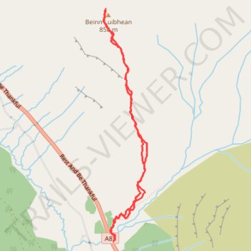
Walk up Beinn Luibhean
- Distance: 3.1 mi
- Elevation gain: 2,251 ft
- Maximum elevation: 2,785 ft
- Elevation loss: 2,244 ft
- Minimum elevation: 535 ft
- Moving time: 2 h 38 m
- Moving speed: 1.2 mph
- Maximum speed: 3.1 mph
- Total time: 3 h 29 m
- Global speed: 0.9 mph
Interactive trail map
Thank you for supporting this site ❤️
Make a donation
Make a donation
Gear up for your next adventure:
As an Amazon Associate, this site earns from qualifying purchases at no extra cost to you.
Trail profile
- Distance: 3.1 mi
- Elevation gain: 2,251 ft
- Maximum elevation: 2,785 ft
- Elevation loss: 2,244 ft
- Minimum elevation: 535 ft
- Moving time: 2 h 38 m
- Moving speed: 1.2 mph
- Maximum speed: 3.1 mph
- Total time: 3 h 29 m
- Global speed: 0.9 mph
Thank you for supporting this site ❤️
Make a donation
Make a donation
Gear up for your next adventure:
As an Amazon Associate, this site earns from qualifying purchases at no extra cost to you.
About this trail
Name: Walk up Beinn Luibhean trail, distance, elevation, map, profile, GPS track
Start: Rest And Be Thankful, Argyll and Bute, Scotland, G83 7AS, United Kingdom (56.21397 -4.83525)
End: Rest And Be Thankful, Argyll and Bute, Scotland, G83 7AS, United Kingdom (56.21409 -4.83519)
Coordinates: 56.21397 -4.83658 56.23136 -4.83065
Thank you for supporting this site ❤️
Make a donation
Make a donation
Gear up for your next adventure:
As an Amazon Associate, this site earns from qualifying purchases at no extra cost to you.
Other hiking, mountain biking, running and outdoor activity trails
Click on a trail to view its statistics, map and profile.