Make a donation
Gear up for your next adventure:
As an Amazon Associate, this site earns from qualifying purchases at no extra cost to you.
Wilman Bilya Trail
- Distance: 7.4 mi
- Elevation gain: 640 ft
- Maximum elevation: 902 ft
- Elevation loss: 630 ft
- Minimum elevation: 568 ft
- Moving time: 1 h 34 m
- Moving speed: 4.7 mph
- Maximum speed: 7.5 mph
- Total time: 1 h 37 m
- Global speed: 4.6 mph
Interactive trail map
Make a donation
Gear up for your next adventure:
As an Amazon Associate, this site earns from qualifying purchases at no extra cost to you.
Trail profile
- Distance: 7.4 mi
- Elevation gain: 640 ft
- Maximum elevation: 902 ft
- Elevation loss: 630 ft
- Minimum elevation: 568 ft
- Moving time: 1 h 34 m
- Moving speed: 4.7 mph
- Maximum speed: 7.5 mph
- Total time: 1 h 37 m
- Global speed: 4.6 mph
Make a donation
Gear up for your next adventure:
As an Amazon Associate, this site earns from qualifying purchases at no extra cost to you.
About this trail
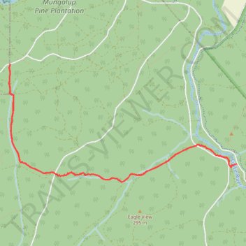
Name: Wilman Bilya Trail trail, distance, elevation, map, profile, GPS track
End: Flora Road, Allanson, Collie, Shire Of Collie, Western Australia, Australia (-33.37099 116.09799)
Coordinates: -33.37366 116.05789 -33.35627 116.09799
Make a donation
Gear up for your next adventure:
As an Amazon Associate, this site earns from qualifying purchases at no extra cost to you.
Other hiking, mountain biking, running and outdoor activity trails
Click on a trail to view its statistics, map and profile.
Wiilman Bilya Trail section Connell road to west
Australia > Western Australia > Mungalup
Distance: 10.5 mi • Elevation gain: 846 ft • Maximum elevation: 810 ft