Wiilman Bilya Trail section Connell road to west
- Distance: 10.5 mi
- Elevation gain: 846 ft
- Maximum elevation: 810 ft
- Elevation loss: 846 ft
- Minimum elevation: 561 ft
- Moving time: 2 h 40 m
- Moving speed: 3.9 mph
- Maximum speed: 7.7 mph
- Total time: 2 h 42 m
- Global speed: 3.9 mph
Interactive trail map
Trail profile
- Distance: 10.5 mi
- Elevation gain: 846 ft
- Maximum elevation: 810 ft
- Elevation loss: 846 ft
- Minimum elevation: 561 ft
- Moving time: 2 h 40 m
- Moving speed: 3.9 mph
- Maximum speed: 7.7 mph
- Total time: 2 h 42 m
- Global speed: 3.9 mph
About this trail
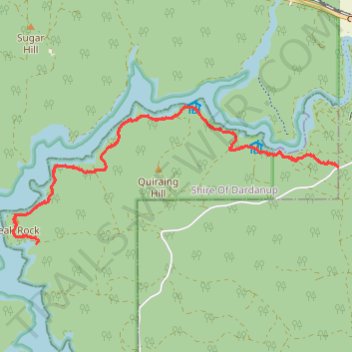
Name: Wiilman Bilya Trail section Connell road to west trail, distance, elevation, map, profile, GPS track
Coordinates: -33.36732 116.00203 -33.34755 116.05799
Other hiking, mountain biking, running and outdoor activity trails
Click on a trail to view its statistics, map and profile.
Wiilman Bilya Trail Connell Road Area
Australia > Western Australia > Mungalup
Distance: 12.0 mi • Elevation gain: 1,476 ft • Maximum elevation: 860 ft
Wilman Bilya Trail
Australia > Western Australia > Collie > Mungalup
Distance: 7.4 mi • Elevation gain: 640 ft • Maximum elevation: 902 ft