Bridal Veil Falls and Lunch Rock via Lake Serene Trail in Mount Baker Snoqualmie National Forest
The hike to Bridal Veil Falls and Lunch Rock is a truly enchanting experience, winding through lush forests filled with the sounds of nature. As you ascend, the captivating views of the rugged mountains and the sparkling waters of Lake Serene come into focus, offering breathtaking photo opportunities along the way. Reaching the picturesque Bridal Veil Falls and the serene Lunch Rock is a rewarding highlight, perfect for soaking in the beauty of the Pacific Northwest. #Hiking #Mountain #Waterfall #Lake #Forest #Nature
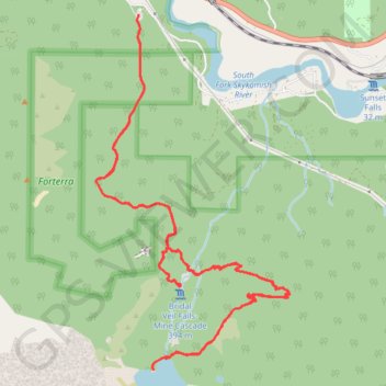
- Distance: 7.9 mi
- Elevation gain: 2,858 ft
- Maximum elevation: 2,621 ft
- Elevation loss: 2,844 ft
- Minimum elevation: 574 ft
- Moving time: 3 h 58 m
- Moving speed: 2.0 mph
- Maximum speed: 6.9 mph
- Total time: 4 h 48 m
- Global speed: 1.6 mph
Interactive trail map
Trail profile
- Distance: 7.9 mi
- Elevation gain: 2,858 ft
- Maximum elevation: 2,621 ft
- Elevation loss: 2,844 ft
- Minimum elevation: 574 ft
- Moving time: 3 h 58 m
- Moving speed: 2.0 mph
- Maximum speed: 6.9 mph
- Total time: 4 h 48 m
- Global speed: 1.6 mph
About this trail
Name: Bridal Veil Falls and Lunch Rock via Lake Serene Trail in Mount Baker Snoqualmie National Forest trail, distance, elevation, map, profile, GPS track
Coordinates: 47.78416 -121.57818 47.80924 -121.55792
Topography: Snohomish County topographic map, elevation, terrain
Other hiking, mountain biking, running and outdoor activity trails
Click on a trail to view its statistics, map and profile.
Bridal Veil Falls via Lake Serene Trail in Mount Baker Snoqualmie National Forest
United States > Washington > Snohomish County
The Lake Serene Trail to Bridal Veil Falls in Washington's Mount Baker-Snoqualmie National Forest offers hikers a journey through lush forests, leading to the majestic Bridal Veil Falls, where water cascades gracefully over towering cliffs. This hike seamlessly blends verdant woodlands, impressive waterfalls,…
Distance: 3.9 mi • Elevation gain: 1,145 ft • Maximum elevation: 1,568 ft
Bridal Veil Falls and Lake Serene in Mount Baker-Snoqualmie National Forest
United States > Washington > Snohomish County
The hike to Bridal Veil Falls and Lake Serene in the Mount Baker-Snoqualmie National Forest offers a rewarding blend of natural beauty and physical challenge. The journey begins with a gentle ascent through lush forests, where towering evergreens and the scent of fresh cedar set a serene tone. After a steep…
Distance: 7.4 mi • Elevation gain: 2,864 ft • Maximum elevation: 2,621 ft
Northern part of the Pacific Crest Trail (PCT)
United States > Oregon > Klamath County
Hike on the Pacific Crest National Scenic Trail from Crater Lake to Canada Border through Oregon and Washington along the Sierra Nevada and Cascade mountain ranges. #Hiking #Mountain #SierraNevada #Cascade #Nature #Forest #Park #PCT
Distance: 744.6 mi • Elevation gain: 145,367 ft • Maximum elevation: 7,569 ft