Make a donation
Gear up for your next adventure:
As an Amazon Associate, this site earns from qualifying purchases at no extra cost to you.
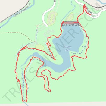
Tucker Lake Loop Trail
- Distance: 6.5 mi
- Elevation gain: 525 ft
- Maximum elevation: 1,234 ft
- Elevation loss: 528 ft
- Minimum elevation: 1,083 ft
- Moving time: 2 h 14 m
- Moving speed: 2.9 mph
- Maximum speed: 6.3 mph
- Total time: 2 h 27 m
- Global speed: 2.6 mph
Interactive trail map
Make a donation
Gear up for your next adventure:
As an Amazon Associate, this site earns from qualifying purchases at no extra cost to you.
Trail profile
- Distance: 6.5 mi
- Elevation gain: 525 ft
- Maximum elevation: 1,234 ft
- Elevation loss: 528 ft
- Minimum elevation: 1,083 ft
- Moving time: 2 h 14 m
- Moving speed: 2.9 mph
- Maximum speed: 6.3 mph
- Total time: 2 h 27 m
- Global speed: 2.6 mph
Make a donation
Gear up for your next adventure:
As an Amazon Associate, this site earns from qualifying purchases at no extra cost to you.
About this trail
Name: Tucker Lake Loop Trail trail, distance, elevation, map, profile, GPS track
Start: Park Road 77, Palo Pinto County, Texas, United States (32.53502 -98.55761)
End: Park Road 77, Palo Pinto County, Texas, United States (32.53509 -98.55757)
Coordinates: 32.52027 -98.57207 32.53666 -98.55707
Topography: Palo Pinto County topographic map, elevation, terrain
Make a donation
Gear up for your next adventure:
As an Amazon Associate, this site earns from qualifying purchases at no extra cost to you.
Other hiking, mountain biking, running and outdoor activity trails
Click on a trail to view its statistics, map and profile.
Palo Pinto Mountains State Park Hiking
United States > Texas > Palo Pinto County
Distance: 13.0 mi • Elevation gain: 505 ft • Maximum elevation: 1,253 ft