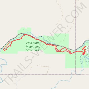
Palo Pinto Mountains State Park Hiking
- Distance: 13.0 mi
- Elevation gain: 505 ft
- Maximum elevation: 1,253 ft
- Elevation loss: 518 ft
- Minimum elevation: 1,102 ft
- Moving time: 4 h 25 m
- Moving speed: 2.9 mph
- Maximum speed: 4.4 mph
- Total time: 4 h 43 m
- Global speed: 2.7 mph
Interactive trail map
Trail profile
- Distance: 13.0 mi
- Elevation gain: 505 ft
- Maximum elevation: 1,253 ft
- Elevation loss: 518 ft
- Minimum elevation: 1,102 ft
- Moving time: 4 h 25 m
- Moving speed: 2.9 mph
- Maximum speed: 4.4 mph
- Total time: 4 h 43 m
- Global speed: 2.7 mph
About this trail
Name: Palo Pinto Mountains State Park Hiking trail, distance, elevation, map, profile, GPS track
Start: Tucker Lake Trail, Palo Pinto County, Texas, United States (32.52968 -98.56977)
End: Palo Pinto County, Texas, United States (32.52961 -98.56869)
Coordinates: 32.52950 -98.63823 32.54398 -98.56737
Topography: Palo Pinto County topographic map, elevation, terrain
Other hiking, mountain biking, running and outdoor activity trails
Click on a trail to view its statistics, map and profile.
Tucker Lake Loop Trail
United States > Texas > Palo Pinto County
Distance: 6.5 mi • Elevation gain: 525 ft • Maximum elevation: 1,234 ft