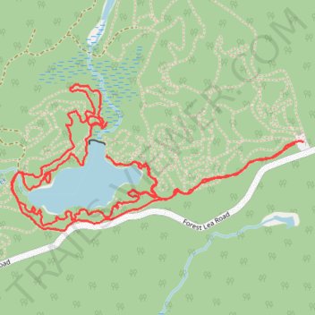
Hiking Forest Lea trails
- Distance: 4.5 mi
- Elevation gain: 167 ft
- Maximum elevation: 610 ft
- Elevation loss: 167 ft
- Minimum elevation: 551 ft
- Moving time: 1 h 48 m
- Moving speed: 2.5 mph
- Maximum speed: 6.0 mph
- Total time: 2 h 2 m
- Global speed: 2.2 mph
Interactive trail map
Trail profile
- Distance: 4.5 mi
- Elevation gain: 167 ft
- Maximum elevation: 610 ft
- Elevation loss: 167 ft
- Minimum elevation: 551 ft
- Moving time: 1 h 48 m
- Moving speed: 2.5 mph
- Maximum speed: 6.0 mph
- Total time: 2 h 2 m
- Global speed: 2.2 mph
About this trail
Name: Hiking Forest Lea trails trail, distance, elevation, map, profile, GPS track
Coordinates: 45.80531 -77.29415 45.81112 -77.27751
Other hiking, mountain biking, running and outdoor activity trails
Click on a trail to view its statistics, map and profile.
Forest Lea Trails
Canada > Ontario > Renfrew County > Laurentian Valley
Distance: 6.7 mi • Elevation gain: 390 ft • Maximum elevation: 643 ft
Hike on the Forest Lea trails
Canada > Ontario > Renfrew County > Laurentian Valley
Distance: 5.1 mi • Elevation gain: 256 ft • Maximum elevation: 669 ft
Forest Lea trails
Canada > Ontario > Renfrew County > Laurentian Valley
Distance: 2.5 mi • Elevation gain: 135 ft • Maximum elevation: 607 ft