Indian Bar Camp via Summerland Trail, Wonderland Trail and Panhandle Gap
This hike to Indian Bar offers a remarkable journey through some of Mount Rainier National Park's most diverse landscapes. Beginning with shaded forests and gradually opening into the expansive meadows of Summerland, the trail rewards hikers with views of cascading waterfalls, wildflower fields, rugged mountain ridgelines and the breathtaking panoramas of Mount Rainier, Little Tahoma, and Fryingpan Glacier. From Panhandle Gap, the highest point on the Wonderland Trail, the descent into Indian Bar reveals a serene valley with glacial streams, lush greenery, and an inviting shelter, making it a visually stunning and rewarding trek. #Hiking #Mountain #Forest #Nature #Glacier
- Distance: 8.7 mi
- Elevation gain: 3,304 ft
- Maximum elevation: 6,775 ft
- Elevation loss: 2,110 ft
- Minimum elevation: 3,871 ft
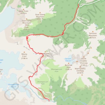
Interactive trail map
Trail profile
- Distance: 8.7 mi
- Elevation gain: 3,304 ft
- Maximum elevation: 6,775 ft
- Elevation loss: 2,110 ft
- Minimum elevation: 3,871 ft
About this trail
Name: Indian Bar Camp via Summerland Trail, Wonderland Trail and Panhandle Gap trail, distance, elevation, map, profile, GPS track
Start: Sunrise Park Road, Pierce County, Washington, United States (46.88991 -121.61092)
End: Wonderland Trail, Pierce County, Washington, United States (46.82635 -121.63908)
Coordinates: 46.82635 -121.66104 46.88991 -121.61051
Topography: Pierce County topographic map, elevation, terrain
Other hiking, mountain biking, running and outdoor activity trails
Click on a trail to view its statistics, map and profile.
Northern part of the Pacific Crest Trail (PCT)
United States > Oregon > Klamath County
Hike on the Pacific Crest National Scenic Trail from Crater Lake to Canada Border through Oregon and Washington along the Sierra Nevada and Cascade mountain ranges. #Hiking #Mountain #SierraNevada #Cascade #Nature #Forest #Park #PCT
Distance: 744.6 mi • Elevation gain: 145,367 ft • Maximum elevation: 7,569 ft
Wonderland Trail from Sunrise Park Road via Fryingpan Creek and Camp Summerland in the Mount Rainier National Park
United States > Washington > Pierce County
Distance: 14.5 mi • Elevation gain: 3,950 ft • Maximum elevation: 6,772 ft
Hike between Camp Summerland and Indian Bar Camp via Wonderland Trail in the Mount Rainier National Park
United States > Washington > Pierce County
Distance: 10.0 mi • Elevation gain: 3,294 ft • Maximum elevation: 6,778 ft