Hike between Camp Summerland and Indian Bar Camp via Wonderland Trail in the Mount Rainier National Park
- Distance: 10.0 mi
- Elevation gain: 3,294 ft
- Maximum elevation: 6,778 ft
- Elevation loss: 3,320 ft
- Minimum elevation: 5,079 ft
- Moving time: 5 h 19 m
- Moving speed: 1.9 mph
- Maximum speed: 4.3 mph
- Total time: 8 h 10 m
- Global speed: 1.2 mph
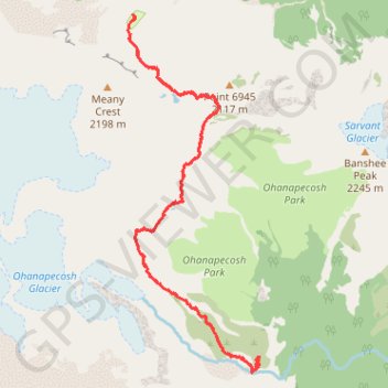
Interactive trail map
Trail profile
- Distance: 10.0 mi
- Elevation gain: 3,294 ft
- Maximum elevation: 6,778 ft
- Elevation loss: 3,320 ft
- Minimum elevation: 5,079 ft
- Moving time: 5 h 19 m
- Moving speed: 1.9 mph
- Maximum speed: 4.3 mph
- Total time: 8 h 10 m
- Global speed: 1.2 mph
About this trail
Name: Hike between Camp Summerland and Indian Bar Camp via Wonderland Trail in the Mount Rainier National Park trail, distance, elevation, map, profile, GPS track
Start: Camp Summerland, Wonderland Trail, Pierce County, Washington, United States (46.86614 -121.65818)
End: Wonderland Trail, Pierce County, Washington, United States (46.86435 -121.65910)
Coordinates: 46.82619 -121.65960 46.86658 -121.63777
Topography: Pierce County topographic map, elevation, terrain
Other hiking, mountain biking, running and outdoor activity trails
Click on a trail to view its statistics, map and profile.
Indian Bar Camp via Summerland Trail, Wonderland Trail and Panhandle Gap
United States > Washington > Pierce County
This hike to Indian Bar offers a remarkable journey through some of Mount Rainier National Park's most diverse landscapes. Beginning with shaded forests and gradually opening into the expansive meadows of Summerland, the trail rewards hikers with views of cascading waterfalls, wildflower fields, rugged…
Distance: 8.7 mi • Elevation gain: 3,304 ft • Maximum elevation: 6,775 ft
Northern part of the Pacific Crest Trail (PCT)
United States > Oregon > Klamath County
Hike on the Pacific Crest National Scenic Trail from Crater Lake to Canada Border through Oregon and Washington along the Sierra Nevada and Cascade mountain ranges. #Hiking #Mountain #SierraNevada #Cascade #Nature #Forest #Park #PCT
Distance: 744.6 mi • Elevation gain: 145,367 ft • Maximum elevation: 7,569 ft
Wonderland Trail from Sunrise Park Road via Fryingpan Creek and Camp Summerland in the Mount Rainier National Park
United States > Washington > Pierce County
Distance: 14.5 mi • Elevation gain: 3,950 ft • Maximum elevation: 6,772 ft