Thank you for supporting this site ❤️
Make a donation
Make a donation
Gear up for your next adventure:
As an Amazon Associate, this site earns from qualifying purchases at no extra cost to you.
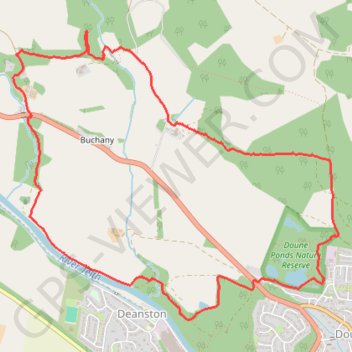
Doune - Buchany
Morning Walk
- Distance: 4.6 mi
- Elevation gain: 449 ft
- Maximum elevation: 318 ft
- Elevation loss: 449 ft
- Minimum elevation: 82 ft
- Moving time: 1 h 41 m
- Moving speed: 2.7 mph
- Maximum speed: 5.7 mph
- Total time: 1 h 41 m
- Global speed: 2.7 mph
Interactive trail map
Thank you for supporting this site ❤️
Make a donation
Make a donation
Gear up for your next adventure:
As an Amazon Associate, this site earns from qualifying purchases at no extra cost to you.
Trail profile
- Distance: 4.6 mi
- Elevation gain: 449 ft
- Maximum elevation: 318 ft
- Elevation loss: 449 ft
- Minimum elevation: 82 ft
- Moving time: 1 h 41 m
- Moving speed: 2.7 mph
- Maximum speed: 5.7 mph
- Total time: 1 h 41 m
- Global speed: 2.7 mph
Thank you for supporting this site ❤️
Make a donation
Make a donation
Gear up for your next adventure:
As an Amazon Associate, this site earns from qualifying purchases at no extra cost to you.
About this trail
Name: Doune - Buchany trail, distance, elevation, map, profile, GPS track
Coordinates: 56.19048 -4.08740 56.20691 -4.05407
Thank you for supporting this site ❤️
Make a donation
Make a donation
Gear up for your next adventure:
As an Amazon Associate, this site earns from qualifying purchases at no extra cost to you.
Other hiking, mountain biking, running and outdoor activity trails
Click on a trail to view its statistics, map and profile.