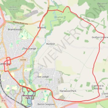
Kettering Half Marathon
- Distance: 13.1 mi
- Elevation gain: 607 ft
- Maximum elevation: 361 ft
- Elevation loss: 610 ft
- Minimum elevation: 194 ft
- Moving time: 1 h 44 m
- Moving speed: 7.5 mph
- Maximum speed: 13.8 mph
- Total time: 1 h 44 m
- Global speed: 7.5 mph
Interactive trail map
Trail profile
- Distance: 13.1 mi
- Elevation gain: 607 ft
- Maximum elevation: 361 ft
- Elevation loss: 610 ft
- Minimum elevation: 194 ft
- Moving time: 1 h 44 m
- Moving speed: 7.5 mph
- Maximum speed: 13.8 mph
- Total time: 1 h 44 m
- Global speed: 7.5 mph
About this trail
Name: Kettering Half Marathon trail, distance, elevation, map, profile, GPS track
Coordinates: 52.37970 -0.72842 52.42917 -0.64318
Other hiking, mountain biking, running and outdoor activity trails
Click on a trail to view its statistics, map and profile.
Walking from Kettering to Northampton via various PRoW paths
United Kingdom > England > North Northamptonshire > Kettering
Distance: 17.1 mi • Elevation gain: 876 ft • Maximum elevation: 384 ft
Walk from Kettering to Corby
United Kingdom > England > North Northamptonshire > Kettering
Distance: 7.9 mi • Elevation gain: 466 ft • Maximum elevation: 397 ft
The Jo Cox Way 2022 Day 3 Market Bosworth to Milton Keynes
United Kingdom > England > Leicestershire > Hinckley and Bosworth > Market Bosworth
Distance: 76.4 mi • Elevation gain: 3,127 ft • Maximum elevation: 640 ft
Cycling around Kettering
United Kingdom > England > North Northamptonshire > Kettering
Kettering Cycling
Distance: 22.4 mi • Elevation gain: 1,181 ft • Maximum elevation: 417 ft
Isham Footpath
United Kingdom > England > North Northamptonshire > Kettering
Evening Run
Distance: 6.3 mi • Elevation gain: 364 ft • Maximum elevation: 282 ft