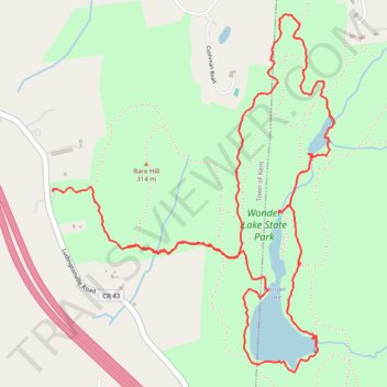
Wonder Lake State Park loop hike
- Distance: 5.6 mi
- Elevation gain: 525 ft
- Maximum elevation: 1,076 ft
- Elevation loss: 719 ft
- Minimum elevation: 679 ft
- Moving time: 3 h 2 m
- Moving speed: 1.8 mph
- Maximum speed: 5.6 mph
- Total time: 4 h 47 m
- Global speed: 1.2 mph
Interactive trail map
Trail profile
- Distance: 5.6 mi
- Elevation gain: 525 ft
- Maximum elevation: 1,076 ft
- Elevation loss: 719 ft
- Minimum elevation: 679 ft
- Moving time: 3 h 2 m
- Moving speed: 1.8 mph
- Maximum speed: 5.6 mph
- Total time: 4 h 47 m
- Global speed: 1.2 mph
About this trail
Name: Wonder Lake State Park loop hike trail, distance, elevation, map, profile, GPS track
Coordinates: 41.48609 -73.66282 41.50343 -73.64462
Topography: Putnam County topographic map, elevation, terrain
Other hiking, mountain biking, running and outdoor activity trails
Click on a trail to view its statistics, map and profile.